Uitweg geodata
Uitweg (Utrecht) is a populated place; located in Netherlands in Europe/Amsterdam (GMT+2) time zone. With population of 525 people, there are 1804 cities with bigger population in this country. Compared to other cities in Netherlands, 52.3% of cities are located further ↑North; 73.1% of cities are located further →East and 83.9% of cities have higher elevation than Uitweg. Note1


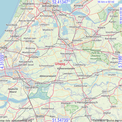
Uitweg GPS coordinates[2]
51° 58' 57" North, 5° 1' 0.012" East
| Map corner | latitude | longitude |
|---|---|---|
| Upper-left | 52.41347°, | 4.31355° |
| Center: | 51.9825°, | 5.01667° |
| Lower-right: | 51.54735°, | 5.7198° |
| Map W x H: | 96.3×96.3 km | = 59.8×59.8mi |
| max Lat: | 53.48025° ⇑52.3% North |
| Uitweg: | 51.9825° |
| min Lat: | ⇓47.7% South 50.76917° |
| min Long | Uitweg | max Long |
| 3.38611° | 5.01667° | 7.16528° |
| W 26.9%⇐ | ⇒73.1% E |
Elevation
Elevation of Uitweg is 1 m = 3 ft, and this is 14 m = 46 ft below average elevation for this country.
| Max E: |
203 m = 666 ft | 83.9% |
| Avg. | 15 m = 49 ft | |
| Uitweg | 1 m = 3 ft | |
Min E: |
-6 m = -20 ft | 16.1% |
See also: Netherlands elevation on elevation.city.
Geographical zone
Uitweg is located in North temperate zone (between Tropic of Cancer and the Arctic Circle). Distance of this North polar circle is 1621.3 km =1007.4 mi to North.| Distance of | km | miles | from Uitweg |
|---|---|---|---|
| North Pole | 4227.1 | 2626.6 | to North |
| Arctic Circle | 1621.3 | 1007.4 | to North |
| Tropic Cancer | 3174 | 1972.2 | to South |
| Equator | 5779.9 | 3591.5 | to South |


Nearby cities:
15 places around Uitweg: (largest is in red/bold)
• Cabauw
8.3 km =5.2 mi,  255°
255°
• De Hagen
6 km =3.7 mi,  77°
77°
• Everdingen
9.7 km =6 mi,  101°
101°
• Graaf
2.6 km =1.6 mi,  265°
265°
• Hagestein
7.2 km =4.5 mi,  91°
91°
• Heeswijk
8.3 km =5.2 mi,  337°
337°
• IJsselstein
4.5 km =2.8 mi,  23°
23°
• Lopik
4.8 km =3 mi, 256°
• Lopikerkapel
2.2 km =1.4 mi,  62°
62°
• Montfoort
8.3 km =5.2 mi,  328°
328°
• Nieuwegein
6.8 km =4.2 mi,  40°
40°
• Snelrewaard
8.9 km =5.5 mi,  304°
304°
• Vianen
5.3 km =3.3 mi, 77°
• Vreeswijk
6.1 km =3.8 mi, 58°
• Zijderveld
9.6 km =6 mi,  118°
118°
Sources, notices
• [Note1] Compared only with cities in Netherlands existing in our database
• [Src1] Map data: © OpenStreetMap contributors (CC-BY-SA)
• [Src2] Other city data from geonames.org with taken over terms of usage.
• [Src3] Geographical zone / Annual Mean Temperature by Robert A. Rohde @ Wikipedia
