Vreeswijk geodata
Vreeswijk (Utrecht) is a section of populated place; located in Netherlands in Europe/Amsterdam (GMT+2) time zone. With population of 3,460 people, there are 683 cities with bigger population in this country. Compared to other cities in Netherlands, 50.2% of cities are located further ↑North; 70.1% of cities are located further →East and 65.8% of cities have higher elevation than Vreeswijk. Note1


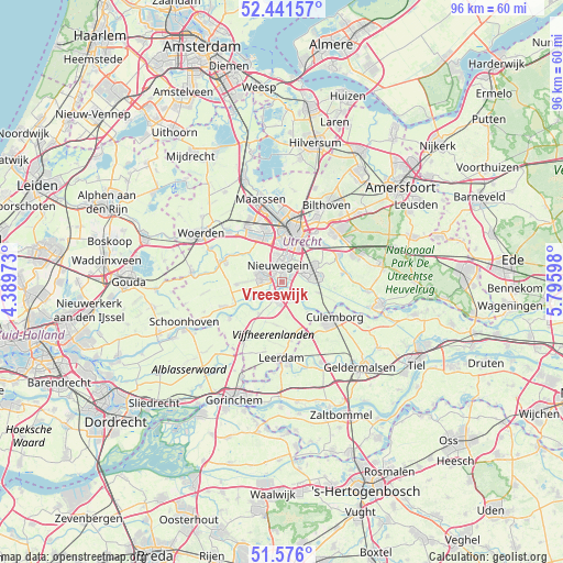
Vreeswijk GPS coordinates[2]
52° 0' 39.168" North, 5° 5' 34.26" East
| Map corner | latitude | longitude |
|---|---|---|
| Upper-left | 52.44157°, | 4.38973° |
| Center: | 52.01088°, | 5.09285° |
| Lower-right: | 51.576°, | 5.79598° |
| Map W x H: | 96.2×96.2 km | = 59.8×59.8mi |
| max Lat: | 53.48025° ⇑50.2% North |
| Vreeswijk: | 52.01088° |
| min Lat: | ⇓49.8% South 50.76917° |
| min Long | Vreeswijk | max Long |
| 3.38611° | 5.09285° | 7.16528° |
| W 29.9%⇐ | ⇒70.1% E |
Elevation
Elevation of Vreeswijk is 3 m = 10 ft, and this is 12 m = 39 ft below average elevation for this country.
| Max E: |
203 m = 666 ft | 65.8% |
| Avg. | 15 m = 49 ft | |
| Vreeswijk | 3 m = 10 ft | |
Min E: |
-6 m = -20 ft | 34.2% |
See also: Netherlands elevation on elevation.city.
Geographical zone
Vreeswijk is located in North temperate zone (between Tropic of Cancer and the Arctic Circle). Distance of this North polar circle is 1618.1 km =1005.4 mi to North.| Distance of | km | miles | from Vreeswijk |
|---|---|---|---|
| North Pole | 4224 | 2624.7 | to North |
| Arctic Circle | 1618.1 | 1005.4 | to North |
| Tropic Cancer | 3177.1 | 1974.2 | to South |
| Equator | 5783.1 | 3593.5 | to South |


Nearby cities:
15 places around Vreeswijk: (largest is in red/bold)
• De Hagen
2 km =1.2 mi,  160°
160°
• Everdingen
6.7 km =4.2 mi,  139°
139°
• Graaf
8.5 km =5.3 mi,  246°
246°
• Hagestein
3.9 km =2.4 mi,  148°
148°
• Houten
5.5 km =3.4 mi,  69°
69°
• IJsselstein
3.6 km =2.2 mi,  286°
286°
• Lopikerkapel
3.9 km =2.4 mi,  236°
236°
• Lunetten
6.3 km =3.9 mi,  26°
26°
• Nieuwegein
2.2 km =1.4 mi,  337°
337°
• Oog in Al
8.4 km =5.2 mi,  356°
356°
• Uitweg
6.1 km =3.8 mi, 238°
• Utrecht
9.1 km =5.7 mi,  12°
12°
• Veldhuizen
9 km =5.6 mi,  322°
322°
• Vianen
2 km =1.2 mi,  182°
182°
• Zijderveld
8.4 km =5.2 mi, 157°
Sources, notices
• [Note1] Compared only with cities in Netherlands existing in our database
• [Src1] Map data: © OpenStreetMap contributors (CC-BY-SA)
• [Src2] Other city data from geonames.org with taken over terms of usage.
• [Src3] Geographical zone / Annual Mean Temperature by Robert A. Rohde @ Wikipedia
