Twekkelerveld geodata
Twekkelerveld (Overijssel) is a section of populated place; located in Netherlands in Europe/Amsterdam (GMT+2) time zone. With population of 4,395 people, there are 546 cities with bigger population in this country. Compared to other cities in Netherlands, 63% of cities are located further ↓South; 96.2% of cities are located further ←West and 89.8% of cities have lower elevation than Twekkelerveld. Note1


Twekkelerveld GPS coordinates[2]
52° 13' 50.304" North, 6° 51' 36.144" East
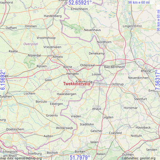
| Map corner | latitude | longitude |
|---|---|---|
| Upper-left | 52.65921°, | 6.15692° |
| Center: | 52.23064°, | 6.86004° |
| Lower-right: | 51.7979°, | 7.56317° |
| Map W x H: | 95.8×95.8 km | = 59.5×59.5mi |
| max Lat: | 53.48025° ⇑37% North |
| Twekkelerveld: | 52.23064° |
| min Lat: | ⇓63% South 50.76917° |
| min Long | Twekkelerveld | max Long |
| 3.38611° | 6.86004° | 7.16528° |
| W 96.2%⇐ | ⇒3.8% E |
Elevation
Elevation of Twekkelerveld is 33 m = 108 ft, and this is 18 m = 59 ft above average elevation for this country.
| Max E: |
203 m = 666 ft | 10.2% |
| Twekkelerveld | 33 m 108 ft | |
| Avg. | 15 m = 49 ft | |
Min E: |
-6 m = -20 ft | 89.8% |
See also: Netherlands elevation on elevation.city.
Geographical zone
Twekkelerveld is located in North temperate zone (between Tropic of Cancer and the Arctic Circle). Distance of this North polar circle is 1593.7 km =990.3 mi to North.| Distance of | km | miles | from Twekkelerveld |
|---|---|---|---|
| North Pole | 4199.6 | 2609.5 | to North |
| Arctic Circle | 1593.7 | 990.3 | to North |
| Tropic Cancer | 3201.6 | 1989.4 | to South |
| Equator | 5807.5 | 3608.6 | to South |


Nearby cities:
15 places around Twekkelerveld: (largest is in red/bold)
• Borne
10.9 km =6.8 mi,  315°
315°
• Delden
10.7 km =6.6 mi,  287°
287°
• Dolphia
6 km =3.7 mi,  102°
102°
• Enschede
2.8 km =1.7 mi,  119°
119°
• Haaksbergen
11.7 km =7.3 mi,  225°
225°
• Hengelo
6 km =3.7 mi,  310°
310°
• Klein Driene
5.2 km =3.2 mi,  325°
325°
• Losser
10.4 km =6.5 mi,  71°
71°
• Mekkelholt
2.2 km =1.4 mi, 72°
• Oldenzaal
10.3 km =6.4 mi,  27°
27°
• Pathmos
2.1 km =1.3 mi,  150°
150°
• Saasveld
11.8 km =7.3 mi,  342°
342°
• Woolde
8.3 km =5.2 mi,  303°
303°
• Wooldrik
4.2 km =2.6 mi,  111°
111°
• Zuid-Berghuizen
9.3 km =5.8 mi, 32°
Sources, notices
• [Note1] Compared only with cities in Netherlands existing in our database
• [Src1] Map data: © OpenStreetMap contributors (CC-BY-SA)
• [Src2] Other city data from geonames.org with taken over terms of usage.
• [Src3] Geographical zone / Annual Mean Temperature by Robert A. Rohde @ Wikipedia
