Saasveld geodata
Saasveld (Overijssel) is a populated place; located in Netherlands in Europe/Amsterdam (GMT+2) time zone. With population of 660 people, there are 1666 cities with bigger population in this country. Compared to other cities in Netherlands, 67.4% of cities are located further ↓South; 95.4% of cities are located further ←West and 70.6% of cities have lower elevation than Saasveld. Note1


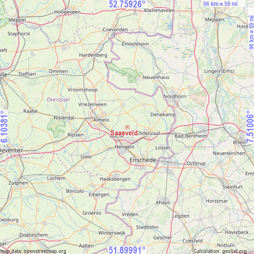
Saasveld GPS coordinates[2]
52° 19' 54.012" North, 6° 48' 24.984" East
| Map corner | latitude | longitude |
|---|---|---|
| Upper-left | 52.75926°, | 6.10381° |
| Center: | 52.33167°, | 6.80694° |
| Lower-right: | 51.89991°, | 7.51006° |
| Map W x H: | 95.6×95.5 km | = 59.4×59.3mi |
| max Lat: | 53.48025° ⇑32.6% North |
| Saasveld: | 52.33167° |
| min Lat: | ⇓67.4% South 50.76917° |
| min Long | Saasveld | max Long |
| 3.38611° | 6.80694° | 7.16528° |
| W 95.4%⇐ | ⇒4.6% E |
Elevation
Elevation of Saasveld is 15 m = 49 ft, and this is 0 m = 0 ft above average elevation for this country.
| Max E: |
203 m = 666 ft | 29.4% |
| Saasveld | 15 m 49 ft | |
| Avg. | 15 m = 49 ft | |
Min E: |
-6 m = -20 ft | 70.6% |
See also: Netherlands elevation on elevation.city.
Geographical zone
Saasveld is located in North temperate zone (between Tropic of Cancer and the Arctic Circle). Distance of this North polar circle is 1582.4 km =983.3 mi to North.| Distance of | km | miles | from Saasveld |
|---|---|---|---|
| North Pole | 4188.3 | 2602.5 | to North |
| Arctic Circle | 1582.4 | 983.3 | to North |
| Tropic Cancer | 3212.8 | 1996.3 | to South |
| Equator | 5818.7 | 3615.6 | to South |


Nearby cities:
15 places around Saasveld: (largest is in red/bold)
• Almelo
10.2 km =6.3 mi,  285°
285°
• Borne
5.2 km =3.2 mi,  229°
229°
• Bornerbroek
10.7 km =6.6 mi,  256°
256°
• Delden
10.3 km =6.4 mi,  219°
219°
• Hengelo
7.4 km =4.6 mi,  187°
187°
• Klein Driene
7 km =4.3 mi,  174°
174°
• Nijrees
9.7 km =6 mi,  272°
272°
• Oldenzaal
8.6 km =5.3 mi,  103°
103°
• Ootmarsum
10.7 km =6.6 mi,  36°
36°
• Rossum
8.1 km =5 mi,  74°
74°
• Tubbergen
8.6 km =5.3 mi,  349°
349°
• Weerselo
4.1 km =2.5 mi,  56°
56°
• Woolde
7.4 km =4.6 mi,  206°
206°
• Zenderen
5.7 km =3.5 mi, 261°
• Zuid-Berghuizen
9.2 km =5.7 mi,  111°
111°
Sources, notices
• [Note1] Compared only with cities in Netherlands existing in our database
• [Src1] Map data: © OpenStreetMap contributors (CC-BY-SA)
• [Src2] Other city data from geonames.org with taken over terms of usage.
• [Src3] Geographical zone / Annual Mean Temperature by Robert A. Rohde @ Wikipedia
