Tilburg geodata
Tilburg (North Brabant) is a populated place; located in Netherlands in Europe/Amsterdam (GMT+2) time zone. With population of 199,613 people, there are 5 cities with bigger population in this country. Compared to other cities in Netherlands, 76.7% of cities are located further ↑North; 70.3% of cities are located further →East and 72.5% of cities have lower elevation than Tilburg. Note1


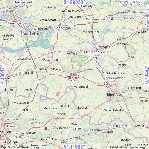
Tilburg GPS coordinates[2]
51° 33' 19.836" North, 5° 5' 28.68" East
| Map corner | latitude | longitude |
|---|---|---|
| Upper-left | 51.99058°, | 4.38817° |
| Center: | 51.55551°, | 5.0913° |
| Lower-right: | 51.11623°, | 5.79442° |
| Map W x H: | 97.2×97.2 km | = 60.4×60.4mi |
| max Lat: | 53.48025° ⇑76.7% North |
| Tilburg: | 51.55551° |
| min Lat: | ⇓23.3% South 50.76917° |
| min Long | Tilburg | max Long |
| 3.38611° | 5.0913° | 7.16528° |
| W 29.7%⇐ | ⇒70.3% E |
Elevation
Elevation of Tilburg is 16 m = 52 ft, and this is 1 m = 3 ft above average elevation for this country.
| Max E: |
203 m = 666 ft | 27.5% |
| Tilburg | 16 m 52 ft | |
| Avg. | 15 m = 49 ft | |
Min E: |
-6 m = -20 ft | 72.5% |
See also: Tilburg elevation on elevation.city.
Geographical zone
Tilburg is located in North temperate zone (between Tropic of Cancer and the Arctic Circle). Distance of this North polar circle is 1668.7 km =1036.9 mi to North.| Distance of | km | miles | from Tilburg |
|---|---|---|---|
| North Pole | 4274.6 | 2656.1 | to North |
| Arctic Circle | 1668.7 | 1036.9 | to North |
| Tropic Cancer | 3126.5 | 1942.7 | to South |
| Equator | 5732.4 | 3561.9 | to South |


Nearby cities:
15 places around Tilburg: (largest is in red/bold)
• Abcoven
3.2 km =2 mi,  190°
190°
• Besterd
1 km =0.6 mi,  340°
340°
• Biest-Houtakker
7.1 km =4.4 mi,  139°
139°
• Broekhoven
0.8 km =0.5 mi,  177°
177°
• De Blaak
3.4 km =2.1 mi,  252°
252°
• De Reit
3 km =1.9 mi,  280°
280°
• Enschot
4.2 km =2.6 mi,  52°
52°
• Goirle
4.2 km =2.6 mi,  203°
203°
• Groenewoud
1.9 km =1.2 mi, 182°
• Groeseind
2.3 km =1.4 mi,  351°
351°
• Korvel
1.6 km =1 mi,  244°
244°
• Loven
1.1 km =0.7 mi,  22°
22°
• Oisterwijk
7.2 km =4.5 mi,  68°
68°
• Quirijnstok
3.2 km =2 mi,  8°
8°
• Udenhout
7 km =4.3 mi,  30°
30°
Sources, notices
• [Note1] Compared only with cities in Netherlands existing in our database
• [Src1] Map data: © OpenStreetMap contributors (CC-BY-SA)
• [Src2] Other city data from geonames.org with taken over terms of usage.
• [Src3] Geographical zone / Annual Mean Temperature by Robert A. Rohde @ Wikipedia
