Oisterwijk geodata
Oisterwijk (North Brabant) is a populated place; located in Netherlands in Europe/Amsterdam (GMT+2) time zone. With population of 25,980 people, there are 125 cities with bigger population in this country. Compared to other cities in Netherlands, 75.1% of cities are located further ↑North; 66.6% of cities are located further →East and 67% of cities have lower elevation than Oisterwijk. Note1


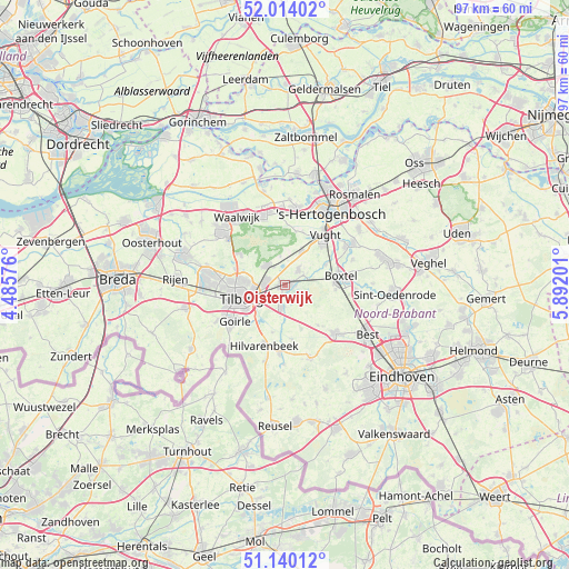
Oisterwijk GPS coordinates[2]
51° 34' 45.012" North, 5° 11' 20.004" East
| Map corner | latitude | longitude |
|---|---|---|
| Upper-left | 52.01402°, | 4.48576° |
| Center: | 51.57917°, | 5.18889° |
| Lower-right: | 51.14012°, | 5.89201° |
| Map W x H: | 97.2×97.2 km | = 60.4×60.4mi |
| max Lat: | 53.48025° ⇑75.1% North |
| Oisterwijk: | 51.57917° |
| min Lat: | ⇓24.9% South 50.76917° |
| min Long | Oisterwijk | max Long |
| 3.38611° | 5.18889° | 7.16528° |
| W 33.4%⇐ | ⇒66.6% E |
Elevation
Elevation of Oisterwijk is 13 m = 43 ft, and this is 2 m = 7 ft below average elevation for this country.
| Max E: |
203 m = 666 ft | 33% |
| Avg. | 15 m = 49 ft | |
| Oisterwijk | 13 m = 43 ft | |
Min E: |
-6 m = -20 ft | 67% |
See also: Netherlands elevation on elevation.city.
Geographical zone
Oisterwijk is located in North temperate zone (between Tropic of Cancer and the Arctic Circle). Distance of this North polar circle is 1666.1 km =1035.3 mi to North.| Distance of | km | miles | from Oisterwijk |
|---|---|---|---|
| North Pole | 4272 | 2654.5 | to North |
| Arctic Circle | 1666.1 | 1035.3 | to North |
| Tropic Cancer | 3129.1 | 1944.3 | to South |
| Equator | 5735.1 | 3563.6 | to South |


Nearby cities:
15 places around Oisterwijk: (largest is in red/bold)
• Besterd
7.3 km =4.5 mi,  256°
256°
• Biest-Houtakker
8.3 km =5.2 mi,  194°
194°
• Biezenmortel
5.1 km =3.2 mi,  351°
351°
• Broekhoven
7.6 km =4.7 mi,  242°
242°
• Enschot
3.5 km =2.2 mi,  268°
268°
• Esch
7.8 km =4.8 mi,  63°
63°
• Groenewoud
8.2 km =5.1 mi, 236°
• Groeseind
7.1 km =4.4 mi, 266°
• Haaren
3.5 km =2.2 mi,  41°
41°
• Helvoirt
6.5 km =4 mi,  26°
26°
• Lennisheuvel
8.8 km =5.5 mi,  94°
94°
• Loven
6.5 km =4 mi, 255°
• Quirijnstok
6.3 km =3.9 mi,  275°
275°
• Tilburg
7.2 km =4.5 mi,  248°
248°
• Udenhout
4.6 km =2.9 mi,  316°
316°
Sources, notices
• [Note1] Compared only with cities in Netherlands existing in our database
• [Src1] Map data: © OpenStreetMap contributors (CC-BY-SA)
• [Src2] Other city data from geonames.org with taken over terms of usage.
• [Src3] Geographical zone / Annual Mean Temperature by Robert A. Rohde @ Wikipedia
