Quirijnstok geodata
Quirijnstok (North Brabant) is a section of populated place; located in Netherlands in Europe/Amsterdam (GMT+1) time zone. With population of 3,970 people, there are 590 cities with bigger population in this country. Compared to other cities in Netherlands, 74.8% of cities are located further ↑North; 70% of cities are located further →East and 67% of cities have lower elevation than Quirijnstok. Note1


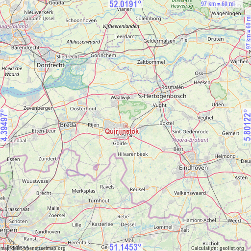
Quirijnstok GPS coordinates[2]
51° 35' 3.48" North, 5° 5' 53.16" East
| Map corner | latitude | longitude |
|---|---|---|
| Upper-left | 52.0191°, | 4.39497° |
| Center: | 51.5843°, | 5.0981° |
| Lower-right: | 51.1453°, | 5.80122° |
| Map W x H: | 97.2×97.2 km | = 60.4×60.4mi |
| max Lat: | 53.48025° ⇑74.8% North |
| Quirijnstok: | 51.5843° |
| min Lat: | ⇓25.2% South 50.76917° |
| min Long | Quirijnstok | max Long |
| 3.38611° | 5.0981° | 7.16528° |
| W 30%⇐ | ⇒70% E |
Elevation
Elevation of Quirijnstok is 13 m = 43 ft, and this is 2 m = 7 ft below average elevation for this country.
| Max E: |
203 m = 666 ft | 33% |
| Avg. | 15 m = 49 ft | |
| Quirijnstok | 13 m = 43 ft | |
Min E: |
-6 m = -20 ft | 67% |
See also: Netherlands elevation on elevation.city.
Geographical zone
Quirijnstok is located in North temperate zone (between Tropic of Cancer and the Arctic Circle). Distance of this North polar circle is 1665.5 km =1034.9 mi to North.| Distance of | km | miles | from Quirijnstok |
|---|---|---|---|
| North Pole | 4271.4 | 2654.1 | to North |
| Arctic Circle | 1665.5 | 1034.9 | to North |
| Tropic Cancer | 3129.7 | 1944.7 | to South |
| Equator | 5735.6 | 3563.9 | to South |


Nearby cities:
15 places around Quirijnstok: (largest is in red/bold)
• Abcoven
6.4 km =4 mi,  189°
189°
• Besterd
2.4 km =1.5 mi,  199°
199°
• Biezenmortel
7.1 km =4.4 mi,  51°
51°
• Broekhoven
4.1 km =2.5 mi, 186°
• De Blaak
5.6 km =3.5 mi,  221°
221°
• De Reit
4.3 km =2.7 mi,  231°
231°
• Enschot
2.9 km =1.8 mi,  102°
102°
• Groenewoud
5.1 km =3.2 mi, 186°
• Groeseind
1.3 km =0.8 mi, 219°
• Korvel
4.3 km =2.7 mi,  206°
206°
• Loon op Zand
5.1 km =3.2 mi,  341°
341°
• Loven
2.2 km =1.4 mi,  181°
181°
• Oisterwijk
6.3 km =3.9 mi, 95°
• Tilburg
3.2 km =2 mi, 188°
• Udenhout
4.2 km =2.6 mi, 48°
Sources, notices
• [Note1] Compared only with cities in Netherlands existing in our database
• [Src1] Map data: © OpenStreetMap contributors (CC-BY-SA)
• [Src2] Other city data from geonames.org with taken over terms of usage.
• [Src3] Geographical zone / Annual Mean Temperature by Robert A. Rohde @ Wikipedia
