Terbregge geodata
Terbregge (South Holland) is a section of populated place; located in Netherlands in Europe/Amsterdam (GMT+2) time zone. With population of 3,525 people, there are 670 cities with bigger population in this country. Compared to other cities in Netherlands, 54.3% of cities are located further ↑North; 88.6% of cities are located further →East and 98.2% of cities have higher elevation than Terbregge. Note1


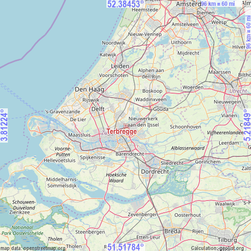
Terbregge GPS coordinates[2]
51° 57' 11.808" North, 4° 30' 55.332" East
| Map corner | latitude | longitude |
|---|---|---|
| Upper-left | 52.38453°, | 3.81224° |
| Center: | 51.95328°, | 4.51537° |
| Lower-right: | 51.51784°, | 5.21849° |
| Map W x H: | 96.4×96.4 km | = 59.9×59.9mi |
| max Lat: | 53.48025° ⇑54.3% North |
| Terbregge: | 51.95328° |
| min Lat: | ⇓45.7% South 50.76917° |
| min Long | Terbregge | max Long |
| 3.38611° | 4.51537° | 7.16528° |
| W 11.4%⇐ | ⇒88.6% E |
Elevation
Elevation of Terbregge is -2 m = -7 ft, and this is 17 m = 56 ft below average elevation for this country.
| Max E: |
203 m = 666 ft | 98.2% |
| Avg. | 15 m = 49 ft | |
| Terbregge | -2 m = -7 ft | |
Min E: |
-6 m = -20 ft | 1.8% |
See also: Netherlands elevation on elevation.city.
Geographical zone
Terbregge is located in North temperate zone (between Tropic of Cancer and the Arctic Circle). Distance of this North polar circle is 1624.5 km =1009.4 mi to North.| Distance of | km | miles | from Terbregge |
|---|---|---|---|
| North Pole | 4230.4 | 2628.6 | to North |
| Arctic Circle | 1624.5 | 1009.4 | to North |
| Tropic Cancer | 3170.7 | 1970.2 | to South |
| Equator | 5776.7 | 3589.5 | to South |


Nearby cities:
15 places around Terbregge: (largest is in red/bold)
• 's-Gravenland
4.2 km =2.6 mi,  142°
142°
• Bergschenhoek
4.2 km =2.6 mi,  344°
344°
• Berkel en Rodenrijs
5.1 km =3.2 mi,  330°
330°
• Bleiswijk
6.5 km =4 mi,  10°
10°
• Bloemhof
6.3 km =3.9 mi,  189°
189°
• Capelle aan den IJssel
5 km =3.1 mi,  122°
122°
• Capelle-West
5.4 km =3.4 mi, 139°
• Feijenoord
4.7 km =2.9 mi, 187°
• Katendrecht
6.3 km =3.9 mi,  201°
201°
• Kop van Zuid
5.7 km =3.5 mi, 200°
• Ommoord
2.2 km =1.4 mi,  71°
71°
• Overschie
6.2 km =3.9 mi,  254°
254°
• Rotterdam
4.2 km =2.6 mi,  215°
215°
• Schiebroek
3.1 km =1.9 mi,  280°
280°
• Spangen
6.8 km =4.2 mi,  233°
233°
Sources, notices
• [Note1] Compared only with cities in Netherlands existing in our database
• [Src1] Map data: © OpenStreetMap contributors (CC-BY-SA)
• [Src2] Other city data from geonames.org with taken over terms of usage.
• [Src3] Geographical zone / Annual Mean Temperature by Robert A. Rohde @ Wikipedia
