Bergschenhoek geodata
Bergschenhoek (South Holland) is a populated place; located in Netherlands in Europe/Amsterdam (GMT+2) time zone. With population of 16,579 people, there are 210 cities with bigger population in this country. Compared to other cities in Netherlands, 51.8% of cities are located further ↑North; 89.1% of cities are located further →East and 99.9% of cities have higher elevation than Bergschenhoek. Note1


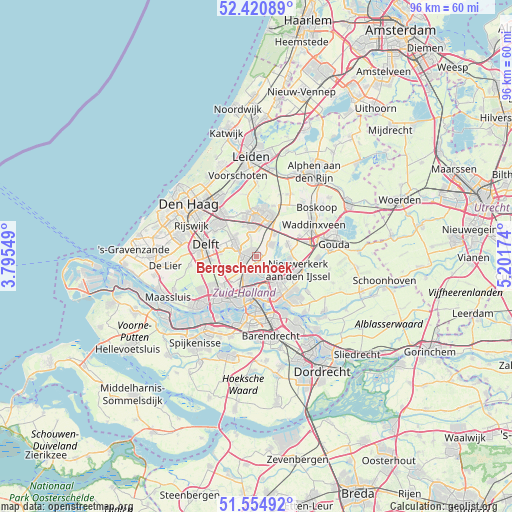
Bergschenhoek GPS coordinates[2]
51° 59' 24" North, 4° 29' 54.996" East
| Map corner | latitude | longitude |
|---|---|---|
| Upper-left | 52.42089°, | 3.79549° |
| Center: | 51.99°, | 4.49861° |
| Lower-right: | 51.55492°, | 5.20174° |
| Map W x H: | 96.3×96.3 km | = 59.8×59.8mi |
| max Lat: | 53.48025° ⇑51.8% North |
| Bergschenhoek: | 51.99° |
| min Lat: | ⇓48.2% South 50.76917° |
| min Long | Bergschenhoek | max Long |
| 3.38611° | 4.49861° | 7.16528° |
| W 10.9%⇐ | ⇒89.1% E |
Elevation
Elevation of Bergschenhoek is -4 m = -13 ft, and this is 19 m = 62 ft below average elevation for this country.
| Max E: |
203 m = 666 ft | 99.9% |
| Avg. | 15 m = 49 ft | |
| Bergschenhoek | -4 m = -13 ft | |
Min E: |
-6 m = -20 ft | 0.1% |
See also: Netherlands elevation on elevation.city.
Geographical zone
Bergschenhoek is located in North temperate zone (between Tropic of Cancer and the Arctic Circle). Distance of this North polar circle is 1620.4 km =1006.9 mi to North.| Distance of | km | miles | from Bergschenhoek |
|---|---|---|---|
| North Pole | 4226.3 | 2626.1 | to North |
| Arctic Circle | 1620.4 | 1006.9 | to North |
| Tropic Cancer | 3174.8 | 1972.7 | to South |
| Equator | 5780.7 | 3592 | to South |


Nearby cities:
15 places around Bergschenhoek: (largest is in red/bold)
• 's-Gravenland
8.3 km =5.2 mi,  153°
153°
• Berkel en Rodenrijs
1.4 km =0.9 mi,  284°
284°
• Bleiswijk
3.3 km =2.1 mi,  44°
44°
• Capelle aan den IJssel
8.7 km =5.4 mi,  141°
141°
• Driemanspolder
6.9 km =4.3 mi,  352°
352°
• Feijenoord
8.7 km =5.4 mi,  176°
176°
• Noordeinde
3.1 km =1.9 mi,  340°
340°
• Ommoord
4.7 km =2.9 mi, 136°
• Overschie
7.5 km =4.7 mi,  220°
220°
• Palenstein
7.3 km =4.5 mi,  5°
5°
• Pijnacker
5.8 km =3.6 mi,  304°
304°
• Rotterdam
7.6 km =4.7 mi,  190°
190°
• Schiebroek
4 km =2.5 mi,  208°
208°
• Terbregge
4.2 km =2.6 mi,  164°
164°
• Zoetermeer
7.5 km =4.7 mi,  357°
357°
Sources, notices
• [Note1] Compared only with cities in Netherlands existing in our database
• [Src1] Map data: © OpenStreetMap contributors (CC-BY-SA)
• [Src2] Other city data from geonames.org with taken over terms of usage.
• [Src3] Geographical zone / Annual Mean Temperature by Robert A. Rohde @ Wikipedia
