's-Gravenland geodata
's-Gravenland (South Holland) is a section of populated place; located in Netherlands in Europe/Amsterdam (GMT+2) time zone. With population of 10,000 people, there are 288 cities with bigger population in this country. Compared to other cities in Netherlands, 55.9% of cities are located further ↑North; 87.6% of cities are located further →East and 96.1% of cities have higher elevation than 's-Gravenland. Note1


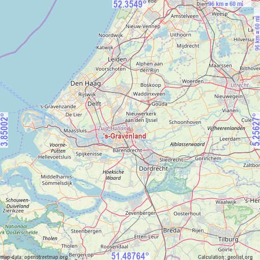
's-Gravenland GPS coordinates[2]
51° 55' 24.096" North, 4° 33' 11.34" East
| Map corner | latitude | longitude |
|---|---|---|
| Upper-left | 52.3549°, | 3.85002° |
| Center: | 51.92336°, | 4.55315° |
| Lower-right: | 51.48764°, | 5.25627° |
| Map W x H: | 96.4×96.4 km | = 59.9×59.9mi |
| max Lat: | 53.48025° ⇑55.9% North |
| 's-Gravenland: | 51.92336° |
| min Lat: | ⇓44.1% South 50.76917° |
| min Long | 's-Gravenland | max Long |
| 3.38611° | 4.55315° | 7.16528° |
| W 12.4%⇐ | ⇒87.6% E |
Elevation
Elevation of 's-Gravenland is -1 m = -3 ft, and this is 16 m = 52 ft below average elevation for this country.
| Max E: |
203 m = 666 ft | 96.1% |
| Avg. | 15 m = 49 ft | |
| 's-Gravenland | -1 m = -3 ft | |
Min E: |
-6 m = -20 ft | 3.9% |
See also: Netherlands elevation on elevation.city.
Geographical zone
's-Gravenland is located in North temperate zone (between Tropic of Cancer and the Arctic Circle). Distance of this North polar circle is 1627.8 km =1011.5 mi to North.| Distance of | km | miles | from 's-Gravenland |
|---|---|---|---|
| North Pole | 4233.7 | 2630.7 | to North |
| Arctic Circle | 1627.8 | 1011.5 | to North |
| Tropic Cancer | 3167.4 | 1968.1 | to South |
| Equator | 5773.3 | 3587.4 | to South |


Nearby cities:
15 places around 's-Gravenland: (largest is in red/bold)
• Bloemhof
4.7 km =2.9 mi,  231°
231°
• Bolnes
3.6 km =2.2 mi,  150°
150°
• Capelle aan den IJssel
1.8 km =1.1 mi,  69°
69°
• Capelle-West
1.2 km =0.7 mi,  128°
128°
• Feijenoord
3.5 km =2.2 mi,  247°
247°
• Groot IJsselmonde
4.5 km =2.8 mi,  183°
183°
• Katendrecht
5.5 km =3.4 mi,  242°
242°
• Kop van Zuid
4.9 km =3 mi, 246°
• Krimpen aan den IJssel
3.5 km =2.2 mi,  102°
102°
• Ommoord
4.1 km =2.5 mi,  352°
352°
• Ouderkerk aan den IJssel
5.8 km =3.6 mi,  78°
78°
• Rotterdam
5.1 km =3.2 mi,  268°
268°
• Slikkerveer
5.5 km =3.4 mi,  139°
139°
• Terbregge
4.2 km =2.6 mi,  322°
322°
• Vreewijk
4.9 km =3 mi,  207°
207°
Sources, notices
• [Note1] Compared only with cities in Netherlands existing in our database
• [Src1] Map data: © OpenStreetMap contributors (CC-BY-SA)
• [Src2] Other city data from geonames.org with taken over terms of usage.
• [Src3] Geographical zone / Annual Mean Temperature by Robert A. Rohde @ Wikipedia
