Stadsfenne geodata
Stadsfenne (Friesland) is a section of populated place; located in Netherlands in Europe/Amsterdam (GMT+2) time zone. With population of 3,060 people, there are 744 cities with bigger population in this country. Compared to other cities in Netherlands, 86.8% of cities are located further ↓South; 51.1% of cities are located further ←West and 83.9% of cities have higher elevation than Stadsfenne. Note1


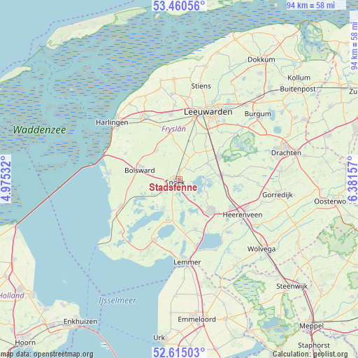
Stadsfenne GPS coordinates[2]
53° 2' 23.532" North, 5° 40' 42.384" East
| Map corner | latitude | longitude |
|---|---|---|
| Upper-left | 53.46056°, | 4.97532° |
| Center: | 53.03987°, | 5.67844° |
| Lower-right: | 52.61503°, | 6.38157° |
| Map W x H: | 94×94 km | = 58.4×58.4mi |
| max Lat: | 53.48025° ⇑13.2% North |
| Stadsfenne: | 53.03987° |
| min Lat: | ⇓86.8% South 50.76917° |
| min Long | Stadsfenne | max Long |
| 3.38611° | 5.67844° | 7.16528° |
| W 51.1%⇐ | ⇒48.9% E |
Elevation
Elevation of Stadsfenne is 1 m = 3 ft, and this is 14 m = 46 ft below average elevation for this country.
| Max E: |
203 m = 666 ft | 83.9% |
| Avg. | 15 m = 49 ft | |
| Stadsfenne | 1 m = 3 ft | |
Min E: |
-6 m = -20 ft | 16.1% |
See also: Netherlands elevation on elevation.city.
Geographical zone
Stadsfenne is located in North temperate zone (between Tropic of Cancer and the Arctic Circle). Distance of this North polar circle is 1503.7 km =934.4 mi to North.| Distance of | km | miles | from Stadsfenne |
|---|---|---|---|
| North Pole | 4109.6 | 2553.6 | to North |
| Arctic Circle | 1503.7 | 934.4 | to North |
| Tropic Cancer | 3291.6 | 2045.3 | to South |
| Equator | 5897.5 | 3664.5 | to South |


Nearby cities:
15 places around Stadsfenne: (largest is in red/bold)
• De Domp
1 km =0.6 mi,  185°
185°
• Heeg
9.1 km =5.7 mi,  209°
209°
• Hommerts
6.9 km =4.3 mi,  196°
196°
• IJlst
5 km =3.1 mi,  228°
228°
• Jirnsum
8.7 km =5.4 mi,  61°
61°
• Langweer
9.5 km =5.9 mi,  162°
162°
• Nijland
6.9 km =4.3 mi,  279°
279°
• Oppenhuizen
3.3 km =2.1 mi, 160°
• Raerd
8.4 km =5.2 mi,  40°
40°
• Scharnegoutum
2.3 km =1.4 mi,  359°
359°
• Sneek
1.5 km =0.9 mi,  239°
239°
• Terherne
7.1 km =4.4 mi,  95°
95°
• Tinga
3.1 km =1.9 mi, 225°
• Wommels
9.8 km =6.1 mi,  321°
321°
• Ysbrechtum
3.1 km =1.9 mi,  272°
272°
Sources, notices
• [Note1] Compared only with cities in Netherlands existing in our database
• [Src1] Map data: © OpenStreetMap contributors (CC-BY-SA)
• [Src2] Other city data from geonames.org with taken over terms of usage.
• [Src3] Geographical zone / Annual Mean Temperature by Robert A. Rohde @ Wikipedia
