Jirnsum geodata
Jirnsum (Friesland) is a populated place; located in Netherlands in Europe/Amsterdam (GMT+2) time zone. With population of 1,255 people, there are 1262 cities with bigger population in this country. Compared to other cities in Netherlands, 88.1% of cities are located further ↓South; 57.3% of cities are located further ←West and 91.3% of cities have higher elevation than Jirnsum. Note1


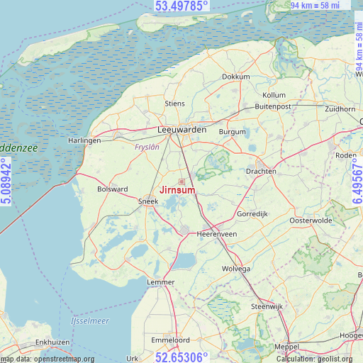
Jirnsum GPS coordinates[2]
53° 4' 39.108" North, 5° 47' 33.144" East
| Map corner | latitude | longitude |
|---|---|---|
| Upper-left | 53.49785°, | 5.08942° |
| Center: | 53.07753°, | 5.79254° |
| Lower-right: | 52.65306°, | 6.49567° |
| Map W x H: | 93.9×93.9 km | = 58.3×58.3mi |
| max Lat: | 53.48025° ⇑11.9% North |
| Jirnsum: | 53.07753° |
| min Lat: | ⇓88.1% South 50.76917° |
| min Long | Jirnsum | max Long |
| 3.38611° | 5.79254° | 7.16528° |
| W 57.3%⇐ | ⇒42.7% E |
Elevation
Elevation of Jirnsum is 0 m = 0 ft, and this is 15 m = 49 ft below average elevation for this country.
| Max E: |
203 m = 666 ft | 91.3% |
| Avg. | 15 m = 49 ft | |
| Jirnsum | 0 m = 0 ft | |
Min E: |
-6 m = -20 ft | 8.7% |
See also: Netherlands elevation on elevation.city.
Geographical zone
Jirnsum is located in North temperate zone (between Tropic of Cancer and the Arctic Circle). Distance of this North polar circle is 1499.5 km =931.7 mi to North.| Distance of | km | miles | from Jirnsum |
|---|---|---|---|
| North Pole | 4105.4 | 2551 | to North |
| Arctic Circle | 1499.5 | 931.7 | to North |
| Tropic Cancer | 3295.7 | 2047.9 | to South |
| Equator | 5901.7 | 3667.1 | to South |


Nearby cities:
15 places around Jirnsum: (largest is in red/bold)
• Akkrum
4 km =2.5 mi,  139°
139°
• Aldeboarn
7.8 km =4.8 mi,  113°
113°
• De Domp
9.3 km =5.8 mi,  236°
236°
• Grou
3.5 km =2.2 mi,  57°
57°
• Mantgum
7.5 km =4.7 mi,  319°
319°
• Nes
4.9 km =3 mi,  125°
125°
• Oppenhuizen
9.8 km =6.1 mi,  221°
221°
• Raerd
3.1 km =1.9 mi, 315°
• Reduzum
4.5 km =2.8 mi,  355°
355°
• Scharnegoutum
7.9 km =4.9 mi,  256°
256°
• Stadsfenne
8.7 km =5.4 mi, 241°
• Terherne
5 km =3.1 mi,  187°
187°
• Warga
8.9 km =5.5 mi,  22°
22°
• Weidum
8.3 km =5.2 mi,  336°
336°
• Wirdum
8 km =5 mi,  5°
5°
Sources, notices
• [Note1] Compared only with cities in Netherlands existing in our database
• [Src1] Map data: © OpenStreetMap contributors (CC-BY-SA)
• [Src2] Other city data from geonames.org with taken over terms of usage.
• [Src3] Geographical zone / Annual Mean Temperature by Robert A. Rohde @ Wikipedia
