Wommels geodata
Wommels (Friesland) is a populated place; located in Netherlands in Europe/Amsterdam (GMT+2) time zone. With population of 2,065 people, there are 942 cities with bigger population in this country. Compared to other cities in Netherlands, 89.2% of cities are located further ↓South; 52.9% of cities are located further →East and 65.8% of cities have higher elevation than Wommels. Note1


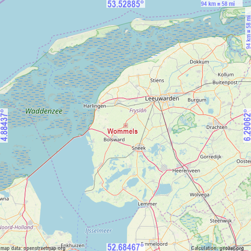
Wommels GPS coordinates[2]
53° 6' 31.788" North, 5° 35' 14.964" East
| Map corner | latitude | longitude |
|---|---|---|
| Upper-left | 53.52885°, | 4.88437° |
| Center: | 53.10883°, | 5.58749° |
| Lower-right: | 52.68467°, | 6.29062° |
| Map W x H: | 93.9×93.9 km | = 58.3×58.3mi |
| max Lat: | 53.48025° ⇑10.8% North |
| Wommels: | 53.10883° |
| min Lat: | ⇓89.2% South 50.76917° |
| min Long | Wommels | max Long |
| 3.38611° | 5.58749° | 7.16528° |
| W 47.1%⇐ | ⇒52.9% E |
Elevation
Elevation of Wommels is 3 m = 10 ft, and this is 12 m = 39 ft below average elevation for this country.
| Max E: |
203 m = 666 ft | 65.8% |
| Avg. | 15 m = 49 ft | |
| Wommels | 3 m = 10 ft | |
Min E: |
-6 m = -20 ft | 34.2% |
See also: Netherlands elevation on elevation.city.
Geographical zone
Wommels is located in North temperate zone (between Tropic of Cancer and the Arctic Circle). Distance of this North polar circle is 1496 km =929.6 mi to North.| Distance of | km | miles | from Wommels |
|---|---|---|---|
| North Pole | 4101.9 | 2548.8 | to North |
| Arctic Circle | 1496 | 929.6 | to North |
| Tropic Cancer | 3299.2 | 2050 | to South |
| Equator | 5905.1 | 3669.3 | to South |


Nearby cities:
15 places around Wommels: (largest is in red/bold)
• Achlum
8.3 km =5.2 mi,  302°
302°
• Arum
7.8 km =4.8 mi,  287°
287°
• Blauwhuis
10.4 km =6.5 mi,  200°
200°
• Bolsward
6.1 km =3.8 mi,  217°
217°
• De Domp
10.5 km =6.5 mi,  145°
145°
• Franeker
9.1 km =5.7 mi,  340°
340°
• Mantgum
9.1 km =5.7 mi,  75°
75°
• Nijland
6.6 km =4.1 mi,  186°
186°
• Scharnegoutum
8.1 km =5 mi,  131°
131°
• Sneek
9.7 km =6 mi, 150°
• Stadsfenne
9.8 km =6.1 mi,  141°
141°
• Tzum
5.8 km =3.6 mi, 343°
• Winsum
5.7 km =3.5 mi,  32°
32°
• Witmarsum
7.9 km =4.9 mi,  266°
266°
• Ysbrechtum
8.1 km =5 mi,  158°
158°
Sources, notices
• [Note1] Compared only with cities in Netherlands existing in our database
• [Src1] Map data: © OpenStreetMap contributors (CC-BY-SA)
• [Src2] Other city data from geonames.org with taken over terms of usage.
• [Src3] Geographical zone / Annual Mean Temperature by Robert A. Rohde @ Wikipedia
