Spoorwijk geodata
Spoorwijk (South Holland) is a section of populated place; located in Netherlands in Europe/Amsterdam (GMT+2) time zone. With population of 4,255 people, there are 561 cities with bigger population in this country. Compared to other cities in Netherlands, 52.1% of cities are located further ↓South; 93.6% of cities are located further →East and 74.9% of cities have higher elevation than Spoorwijk. Note1


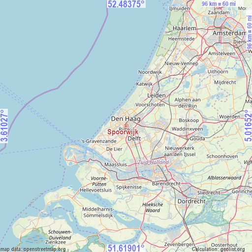
Spoorwijk GPS coordinates[2]
52° 3' 12.492" North, 4° 18' 48.204" East
| Map corner | latitude | longitude |
|---|---|---|
| Upper-left | 52.48375°, | 3.61027° |
| Center: | 52.05347°, | 4.31339° |
| Lower-right: | 51.61901°, | 5.01652° |
| Map W x H: | 96.2×96.1 km | = 59.8×59.7mi |
| max Lat: | 53.48025° ⇑47.9% North |
| Spoorwijk: | 52.05347° |
| min Lat: | ⇓52.1% South 50.76917° |
| min Long | Spoorwijk | max Long |
| 3.38611° | 4.31339° | 7.16528° |
| W 6.4%⇐ | ⇒93.6% E |
Elevation
Elevation of Spoorwijk is 2 m = 7 ft, and this is 13 m = 43 ft below average elevation for this country.
| Max E: |
203 m = 666 ft | 74.9% |
| Avg. | 15 m = 49 ft | |
| Spoorwijk | 2 m = 7 ft | |
Min E: |
-6 m = -20 ft | 25.1% |
See also: Netherlands elevation on elevation.city.
Geographical zone
Spoorwijk is located in North temperate zone (between Tropic of Cancer and the Arctic Circle). Distance of this North polar circle is 1613.4 km =1002.5 mi to North.| Distance of | km | miles | from Spoorwijk |
|---|---|---|---|
| North Pole | 4219.3 | 2621.8 | to North |
| Arctic Circle | 1613.4 | 1002.5 | to North |
| Tropic Cancer | 3181.9 | 1977.1 | to South |
| Equator | 5787.8 | 3596.4 | to South |


Nearby cities:
15 places around Spoorwijk: (largest is in red/bold)
• Delft
5.9 km =3.7 mi,  150°
150°
• Duindorp
5.5 km =3.4 mi,  318°
318°
• Duinzigt
5.8 km =3.6 mi,  7°
7°
• Essesteijn
5.4 km =3.4 mi,  48°
48°
• Kwintsheul
6 km =3.7 mi,  221°
221°
• Plaspoelpolder
2.1 km =1.3 mi,  142°
142°
• Rijswijk
2.1 km =1.3 mi,  157°
157°
• Scheveningen
6.2 km =3.9 mi,  335°
335°
• Sion
4.4 km =2.7 mi,  169°
169°
• Statenkwartier
5.1 km =3.2 mi,  329°
329°
• Strijp
2.6 km =1.6 mi,  198°
198°
• The Hague
2.8 km =1.7 mi, 338°
• Vogelwijk
5.1 km =3.2 mi,  299°
299°
• Voorburg
3.9 km =2.4 mi, 53°
• Ypenburg
4.1 km =2.5 mi,  109°
109°
Sources, notices
• [Note1] Compared only with cities in Netherlands existing in our database
• [Src1] Map data: © OpenStreetMap contributors (CC-BY-SA)
• [Src2] Other city data from geonames.org with taken over terms of usage.
• [Src3] Geographical zone / Annual Mean Temperature by Robert A. Rohde @ Wikipedia
