Kwintsheul geodata
Kwintsheul (South Holland) is a populated place; located in Netherlands in Europe/Amsterdam (GMT+2) time zone. With population of 3,560 people, there are 661 cities with bigger population in this country. Compared to other cities in Netherlands, 50.1% of cities are located further ↑North; 94.3% of cities are located further →East and 91.3% of cities have higher elevation than Kwintsheul. Note1


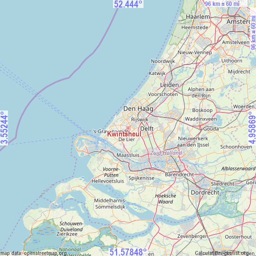
Kwintsheul GPS coordinates[2]
52° 0' 47.988" North, 4° 15' 20.016" East
| Map corner | latitude | longitude |
|---|---|---|
| Upper-left | 52.444°, | 3.55244° |
| Center: | 52.01333°, | 4.25556° |
| Lower-right: | 51.57848°, | 4.95869° |
| Map W x H: | 96.2×96.2 km | = 59.8×59.8mi |
| max Lat: | 53.48025° ⇑50.1% North |
| Kwintsheul: | 52.01333° |
| min Lat: | ⇓49.9% South 50.76917° |
| min Long | Kwintsheul | max Long |
| 3.38611° | 4.25556° | 7.16528° |
| W 5.7%⇐ | ⇒94.3% E |
Elevation
Elevation of Kwintsheul is 0 m = 0 ft, and this is 15 m = 49 ft below average elevation for this country.
| Max E: |
203 m = 666 ft | 91.3% |
| Avg. | 15 m = 49 ft | |
| Kwintsheul | 0 m = 0 ft | |
Min E: |
-6 m = -20 ft | 8.7% |
See also: Netherlands elevation on elevation.city.
Geographical zone
Kwintsheul is located in North temperate zone (between Tropic of Cancer and the Arctic Circle). Distance of this North polar circle is 1617.8 km =1005.3 mi to North.| Distance of | km | miles | from Kwintsheul |
|---|---|---|---|
| North Pole | 4223.7 | 2624.5 | to North |
| Arctic Circle | 1617.8 | 1005.3 | to North |
| Tropic Cancer | 3177.4 | 1974.3 | to South |
| Equator | 5783.3 | 3593.6 | to South |


Nearby cities:
15 places around Kwintsheul: (largest is in red/bold)
• 's-Gravenzande
6.3 km =3.9 mi,  258°
258°
• De Lier
4.3 km =2.7 mi,  186°
186°
• Heenweg
6.2 km =3.9 mi,  235°
235°
• Honselersdijk
2.3 km =1.4 mi,  250°
250°
• Kijkduin
6.5 km =4 mi,  339°
339°
• Monster
5.7 km =3.5 mi,  284°
284°
• Naaldwijk
3.8 km =2.4 mi, 235°
• Plaspoelpolder
5.9 km =3.7 mi,  61°
61°
• Poeldijk
2.7 km =1.7 mi,  295°
295°
• Rijswijk
5.4 km =3.4 mi, 61°
• Schipluiden
5.8 km =3.6 mi,  136°
136°
• Sion
4.8 km =3 mi,  88°
88°
• Spoorwijk
6 km =3.7 mi,  41°
41°
• Strijp
3.7 km =2.3 mi, 58°
• Ter Heijde
6.3 km =3.9 mi,  287°
287°
Sources, notices
• [Note1] Compared only with cities in Netherlands existing in our database
• [Src1] Map data: © OpenStreetMap contributors (CC-BY-SA)
• [Src2] Other city data from geonames.org with taken over terms of usage.
• [Src3] Geographical zone / Annual Mean Temperature by Robert A. Rohde @ Wikipedia
