Plaspoelpolder geodata
Plaspoelpolder (South Holland) is a section of populated place; located in Netherlands in Europe/Amsterdam (GMT+2) time zone. With population of 600 people, there are 1720 cities with bigger population in this country. Compared to other cities in Netherlands, 51.2% of cities are located further ↓South; 93% of cities are located further →East and 74.9% of cities have higher elevation than Plaspoelpolder. Note1


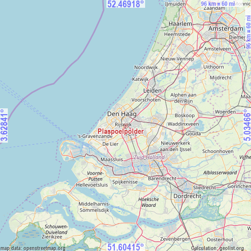
Plaspoelpolder GPS coordinates[2]
52° 2' 19.536" North, 4° 19' 53.508" East
| Map corner | latitude | longitude |
|---|---|---|
| Upper-left | 52.46918°, | 3.62841° |
| Center: | 52.03876°, | 4.33153° |
| Lower-right: | 51.60415°, | 5.03466° |
| Map W x H: | 96.2×96.2 km | = 59.8×59.8mi |
| max Lat: | 53.48025° ⇑48.8% North |
| Plaspoelpolder: | 52.03876° |
| min Lat: | ⇓51.2% South 50.76917° |
| min Long | Plaspoelpolder | max Long |
| 3.38611° | 4.33153° | 7.16528° |
| W 7%⇐ | ⇒93% E |
Elevation
Elevation of Plaspoelpolder is 2 m = 7 ft, and this is 13 m = 43 ft below average elevation for this country.
| Max E: |
203 m = 666 ft | 74.9% |
| Avg. | 15 m = 49 ft | |
| Plaspoelpolder | 2 m = 7 ft | |
Min E: |
-6 m = -20 ft | 25.1% |
See also: Netherlands elevation on elevation.city.
Geographical zone
Plaspoelpolder is located in North temperate zone (between Tropic of Cancer and the Arctic Circle). Distance of this North polar circle is 1615 km =1003.5 mi to North.| Distance of | km | miles | from Plaspoelpolder |
|---|---|---|---|
| North Pole | 4220.9 | 2622.7 | to North |
| Arctic Circle | 1615 | 1003.5 | to North |
| Tropic Cancer | 3180.2 | 1976.1 | to South |
| Equator | 5786.2 | 3595.4 | to South |


Nearby cities:
15 places around Plaspoelpolder: (largest is in red/bold)
• Delft
3.9 km =2.4 mi,  155°
155°
• Duinzigt
7.4 km =4.6 mi,  356°
356°
• Essesteijn
5.9 km =3.7 mi,  28°
28°
• Kwintsheul
5.9 km =3.7 mi,  241°
241°
• Pijnacker
7 km =4.3 mi,  107°
107°
• Rijswijk
0.5 km =0.3 mi, 238°
• Schipluiden
7.1 km =4.4 mi,  189°
189°
• Sion
2.8 km =1.7 mi, 189°
• Spoorwijk
2.1 km =1.3 mi,  322°
322°
• Statenkwartier
7.1 km =4.4 mi,  327°
327°
• Strijp
2.2 km =1.4 mi,  246°
246°
• The Hague
4.8 km =3 mi, 331°
• Vogelwijk
7.1 km =4.4 mi,  306°
306°
• Voorburg
4.4 km =2.7 mi, 26°
• Ypenburg
2.6 km =1.6 mi,  84°
84°
Sources, notices
• [Note1] Compared only with cities in Netherlands existing in our database
• [Src1] Map data: © OpenStreetMap contributors (CC-BY-SA)
• [Src2] Other city data from geonames.org with taken over terms of usage.
• [Src3] Geographical zone / Annual Mean Temperature by Robert A. Rohde @ Wikipedia
