Sleen geodata
Sleen (Drenthe) is a populated place; located in Netherlands in Europe/Amsterdam (GMT+2) time zone. With population of 2,200 people, there are 910 cities with bigger population in this country. Compared to other cities in Netherlands, 78.8% of cities are located further ↓South; 95.3% of cities are located further ←West and 74.9% of cities have lower elevation than Sleen. Note1


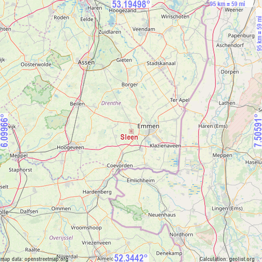
Sleen GPS coordinates[2]
52° 46' 18.012" North, 6° 48' 10.008" East
| Map corner | latitude | longitude |
|---|---|---|
| Upper-left | 53.19498°, | 6.09966° |
| Center: | 52.77167°, | 6.80278° |
| Lower-right: | 52.3442°, | 7.50591° |
| Map W x H: | 94.6×94.6 km | = 58.8×58.8mi |
| max Lat: | 53.48025° ⇑21.2% North |
| Sleen: | 52.77167° |
| min Lat: | ⇓78.8% South 50.76917° |
| min Long | Sleen | max Long |
| 3.38611° | 6.80278° | 7.16528° |
| W 95.3%⇐ | ⇒4.7% E |
Elevation
Elevation of Sleen is 18 m = 59 ft, and this is 3 m = 10 ft above average elevation for this country.
| Max E: |
203 m = 666 ft | 25.1% |
| Sleen | 18 m 59 ft | |
| Avg. | 15 m = 49 ft | |
Min E: |
-6 m = -20 ft | 74.9% |
See also: Netherlands elevation on elevation.city.
Geographical zone
Sleen is located in North temperate zone (between Tropic of Cancer and the Arctic Circle). Distance of this North polar circle is 1533.5 km =952.9 mi to North.| Distance of | km | miles | from Sleen |
|---|---|---|---|
| North Pole | 4139.4 | 2572.1 | to North |
| Arctic Circle | 1533.5 | 952.9 | to North |
| Tropic Cancer | 3261.7 | 2026.7 | to South |
| Equator | 5867.7 | 3646 | to South |


Nearby cities:
15 places around Sleen: (largest is in red/bold)
• Aalden
6.1 km =3.8 mi,  289°
289°
• Angelslo
8.4 km =5.2 mi,  82°
82°
• Bargeres
5.4 km =3.4 mi,  102°
102°
• Dalen
8.7 km =5.4 mi,  201°
201°
• Emmen
7.1 km =4.4 mi, 83°
• Emmerhout
9.3 km =5.8 mi, 79°
• Emmermeer
6.9 km =4.3 mi,  62°
62°
• Gees
8.1 km =5 mi,  250°
250°
• Klijndijk
7.7 km =4.8 mi,  29°
29°
• Noordbarge
5.7 km =3.5 mi,  89°
89°
• Odoorn
9.2 km =5.7 mi,  20°
20°
• Oosterhesselen
5.8 km =3.6 mi, 250°
• Schoonoord
8.8 km =5.5 mi,  338°
338°
• Veenoord
7.4 km =4.6 mi,  155°
155°
• Weerdinge
9.4 km =5.8 mi, 55°
Sources, notices
• [Note1] Compared only with cities in Netherlands existing in our database
• [Src1] Map data: © OpenStreetMap contributors (CC-BY-SA)
• [Src2] Other city data from geonames.org with taken over terms of usage.
• [Src3] Geographical zone / Annual Mean Temperature by Robert A. Rohde @ Wikipedia
