Gees geodata
Gees (Drenthe) is a populated place; located in Netherlands in Europe/Amsterdam (GMT+2) time zone. With population of 530 people, there are 1796 cities with bigger population in this country. Compared to other cities in Netherlands, 78.1% of cities are located further ↓South; 93.1% of cities are located further ←West and 73.5% of cities have lower elevation than Gees. Note1


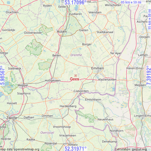
Gees GPS coordinates[2]
52° 44' 50.676" North, 6° 41' 19.644" East
| Map corner | latitude | longitude |
|---|---|---|
| Upper-left | 53.17096°, | 5.98567° |
| Center: | 52.74741°, | 6.68879° |
| Lower-right: | 52.31971°, | 7.39192° |
| Map W x H: | 94.7×94.6 km | = 58.8×58.8mi |
| max Lat: | 53.48025° ⇑21.9% North |
| Gees: | 52.74741° |
| min Lat: | ⇓78.1% South 50.76917° |
| min Long | Gees | max Long |
| 3.38611° | 6.68879° | 7.16528° |
| W 93.1%⇐ | ⇒6.9% E |
Elevation
Elevation of Gees is 17 m = 56 ft, and this is 2 m = 7 ft above average elevation for this country.
| Max E: |
203 m = 666 ft | 26.5% |
| Gees | 17 m 56 ft | |
| Avg. | 15 m = 49 ft | |
Min E: |
-6 m = -20 ft | 73.5% |
See also: Netherlands elevation on elevation.city.
Geographical zone
Gees is located in North temperate zone (between Tropic of Cancer and the Arctic Circle). Distance of this North polar circle is 1536.2 km =954.6 mi to North.| Distance of | km | miles | from Gees |
|---|---|---|---|
| North Pole | 4142.1 | 2573.8 | to North |
| Arctic Circle | 1536.2 | 954.6 | to North |
| Tropic Cancer | 3259 | 2025 | to South |
| Equator | 5865 | 3644.3 | to South |


Nearby cities:
15 places around Gees: (largest is in red/bold)
• Aalden
5.1 km =3.2 mi,  22°
22°
• Ballast
8.9 km =5.5 mi,  160°
160°
• Coevorden
10.2 km =6.3 mi, 160°
• Dalen
7 km =4.3 mi,  140°
140°
• Dalerpeel
7.7 km =4.8 mi,  194°
194°
• De Loo
9.1 km =5.7 mi, 157°
• Geesbrug
4.4 km =2.7 mi,  238°
238°
• Krakeel
12.2 km =7.6 mi,  257°
257°
• Nieuw-Balinge
5.9 km =3.7 mi,  291°
291°
• Oosterhesselen
2.4 km =1.5 mi,  71°
71°
• Schoonoord
11.8 km =7.3 mi, 22°
• Sleen
8.1 km =5 mi, 70°
• Steenwijksmoer
8.7 km =5.4 mi,  175°
175°
• Veenoord
11.5 km =7.1 mi,  110°
110°
• Westerbork
12.6 km =7.8 mi,  334°
334°
Sources, notices
• [Note1] Compared only with cities in Netherlands existing in our database
• [Src1] Map data: © OpenStreetMap contributors (CC-BY-SA)
• [Src2] Other city data from geonames.org with taken over terms of usage.
• [Src3] Geographical zone / Annual Mean Temperature by Robert A. Rohde @ Wikipedia
