Oosterhesselen geodata
Oosterhesselen (Drenthe) is a populated place; located in Netherlands in Europe/Amsterdam (GMT+2) time zone. With population of 1,690 people, there are 1047 cities with bigger population in this country. Compared to other cities in Netherlands, 78.3% of cities are located further ↓South; 93.9% of cities are located further ←West and 72.5% of cities have lower elevation than Oosterhesselen. Note1


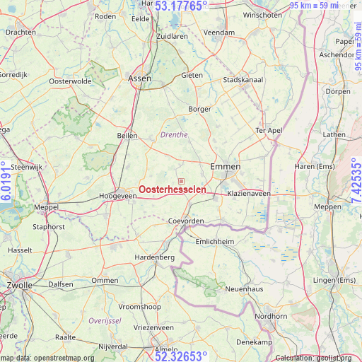
Oosterhesselen GPS coordinates[2]
52° 45' 15.012" North, 6° 43' 19.992" East
| Map corner | latitude | longitude |
|---|---|---|
| Upper-left | 53.17765°, | 6.0191° |
| Center: | 52.75417°, | 6.72222° |
| Lower-right: | 52.32653°, | 7.42535° |
| Map W x H: | 94.6×94.6 km | = 58.8×58.8mi |
| max Lat: | 53.48025° ⇑21.7% North |
| Oosterhesselen: | 52.75417° |
| min Lat: | ⇓78.3% South 50.76917° |
| min Long | Oosterhesselen | max Long |
| 3.38611° | 6.72222° | 7.16528° |
| W 93.9%⇐ | ⇒6.1% E |
Elevation
Elevation of Oosterhesselen is 16 m = 52 ft, and this is 1 m = 3 ft above average elevation for this country.
| Max E: |
203 m = 666 ft | 27.5% |
| Oosterhesselen | 16 m 52 ft | |
| Avg. | 15 m = 49 ft | |
Min E: |
-6 m = -20 ft | 72.5% |
See also: Netherlands elevation on elevation.city.
Geographical zone
Oosterhesselen is located in North temperate zone (between Tropic of Cancer and the Arctic Circle). Distance of this North polar circle is 1535.5 km =954.1 mi to North.| Distance of | km | miles | from Oosterhesselen |
|---|---|---|---|
| North Pole | 4141.3 | 2573.3 | to North |
| Arctic Circle | 1535.5 | 954.1 | to North |
| Tropic Cancer | 3259.8 | 2025.5 | to South |
| Equator | 5865.7 | 3644.8 | to South |


Nearby cities:
15 places around Oosterhesselen: (largest is in red/bold)
• Aalden
4 km =2.5 mi,  355°
355°
• Ballast
9.1 km =5.7 mi,  175°
175°
• Bargeres
10.7 km =6.6 mi,  85°
85°
• Coevorden
10.4 km =6.5 mi,  173°
173°
• Dalen
6.5 km =4 mi,  159°
159°
• Dalerpeel
9.3 km =5.8 mi,  207°
207°
• De Loo
9.2 km =5.7 mi, 172°
• Gees
2.4 km =1.5 mi,  251°
251°
• Geesbrug
6.7 km =4.2 mi,  242°
242°
• Nieuw-Balinge
7.9 km =4.9 mi,  280°
280°
• Noordbarge
11.3 km =7 mi,  79°
79°
• Schoonoord
10.4 km =6.5 mi,  12°
12°
• Sleen
5.8 km =3.6 mi,  70°
70°
• Steenwijksmoer
9.6 km =6 mi,  189°
189°
• Veenoord
9.8 km =6.1 mi,  119°
119°
Sources, notices
• [Note1] Compared only with cities in Netherlands existing in our database
• [Src1] Map data: © OpenStreetMap contributors (CC-BY-SA)
• [Src2] Other city data from geonames.org with taken over terms of usage.
• [Src3] Geographical zone / Annual Mean Temperature by Robert A. Rohde @ Wikipedia
