Schijndel geodata
Schijndel (North Brabant) is a populated place; located in Netherlands in Europe/Amsterdam (GMT+2) time zone. With population of 23,239 people, there are 146 cities with bigger population in this country. Compared to other cities in Netherlands, 72.8% of cities are located further ↑North; 59.4% of cities are located further →East and 59.4% of cities have lower elevation than Schijndel. Note1


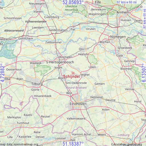
Schijndel GPS coordinates[2]
51° 37' 21" North, 5° 25' 54.984" East
| Map corner | latitude | longitude |
|---|---|---|
| Upper-left | 52.05693°, | 4.72882° |
| Center: | 51.6225°, | 5.43194° |
| Lower-right: | 51.18387°, | 6.13507° |
| Map W x H: | 97.1×97.1 km | = 60.3×60.3mi |
| max Lat: | 53.48025° ⇑72.8% North |
| Schijndel: | 51.6225° |
| min Lat: | ⇓27.2% South 50.76917° |
| min Long | Schijndel | max Long |
| 3.38611° | 5.43194° | 7.16528° |
| W 40.6%⇐ | ⇒59.4% E |
Elevation
Elevation of Schijndel is 10 m = 33 ft, and this is 5 m = 16 ft below average elevation for this country.
| Max E: |
203 m = 666 ft | 40.6% |
| Avg. | 15 m = 49 ft | |
| Schijndel | 10 m = 33 ft | |
Min E: |
-6 m = -20 ft | 59.4% |
See also: Netherlands elevation on elevation.city.
Geographical zone
Schijndel is located in North temperate zone (between Tropic of Cancer and the Arctic Circle). Distance of this North polar circle is 1661.3 km =1032.3 mi to North.| Distance of | km | miles | from Schijndel |
|---|---|---|---|
| North Pole | 4267.2 | 2651.5 | to North |
| Arctic Circle | 1661.3 | 1032.3 | to North |
| Tropic Cancer | 3134 | 1947.4 | to South |
| Equator | 5739.9 | 3566.6 | to South |


Nearby cities:
15 places around Schijndel: (largest is in red/bold)
• Berlicum
6.5 km =4 mi,  340°
340°
• Den Dungen
6.3 km =3.9 mi,  318°
318°
• Eerde
5 km =3.1 mi,  113°
113°
• Eerschot
6.7 km =4.2 mi,  154°
154°
• Gemonde
5.2 km =3.2 mi,  264°
264°
• Heeswijk-Dinther
4.3 km =2.7 mi,  43°
43°
• Leest
7.8 km =4.8 mi,  100°
100°
• Liempde
7.2 km =4.5 mi,  214°
214°
• Maaskantje
5.8 km =3.6 mi,  313°
313°
• Middelrode
4.7 km =2.9 mi,  349°
349°
• Olland
4.9 km =3 mi,  200°
200°
• Sint-Michielsgestel
5.9 km =3.7 mi,  291°
291°
• Sint-Oedenrode
6.4 km =4 mi,  162°
162°
• Theereheide
6.8 km =4.2 mi, 285°
• Wijbosch
2.6 km =1.6 mi, 104°
Sources, notices
• [Note1] Compared only with cities in Netherlands existing in our database
• [Src1] Map data: © OpenStreetMap contributors (CC-BY-SA)
• [Src2] Other city data from geonames.org with taken over terms of usage.
• [Src3] Geographical zone / Annual Mean Temperature by Robert A. Rohde @ Wikipedia
