Berlicum geodata
Berlicum (North Brabant) is a populated place; located in Netherlands in Europe/Amsterdam (GMT+2) time zone. With population of 4,250 people, there are 562 cities with bigger population in this country. Compared to other cities in Netherlands, 70% of cities are located further ↑North; 60.6% of cities are located further →East and 50.6% of cities have higher elevation than Berlicum. Note1


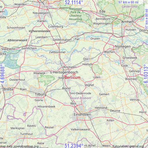
Berlicum GPS coordinates[2]
51° 40' 39" North, 5° 24' 0" East
| Map corner | latitude | longitude |
|---|---|---|
| Upper-left | 52.1114°, | 4.69688° |
| Center: | 51.6775°, | 5.4° |
| Lower-right: | 51.2394°, | 6.10313° |
| Map W x H: | 97×97 km | = 60.3×60.3mi |
| max Lat: | 53.48025° ⇑70% North |
| Berlicum: | 51.6775° |
| min Lat: | ⇓30% South 50.76917° |
| min Long | Berlicum | max Long |
| 3.38611° | 5.4° | 7.16528° |
| W 39.4%⇐ | ⇒60.6% E |
Elevation
Elevation of Berlicum is 6 m = 20 ft, and this is 9 m = 30 ft below average elevation for this country.
| Max E: |
203 m = 666 ft | 50.6% |
| Avg. | 15 m = 49 ft | |
| Berlicum | 6 m = 20 ft | |
Min E: |
-6 m = -20 ft | 49.4% |
See also: Netherlands elevation on elevation.city.
Geographical zone
Berlicum is located in North temperate zone (between Tropic of Cancer and the Arctic Circle). Distance of this North polar circle is 1655.2 km =1028.5 mi to North.| Distance of | km | miles | from Berlicum |
|---|---|---|---|
| North Pole | 4261.1 | 2647.7 | to North |
| Arctic Circle | 1655.2 | 1028.5 | to North |
| Tropic Cancer | 3140.1 | 1951.2 | to South |
| Equator | 5746 | 3570.4 | to South |


Nearby cities:
15 places around Berlicum: (largest is in red/bold)
• 's-Hertogenbosch
7 km =4.3 mi,  290°
290°
• De Rompert
7.2 km =4.5 mi,  307°
307°
• Den Dungen
2.4 km =1.5 mi,  234°
234°
• Gemonde
7.2 km =4.5 mi,  204°
204°
• Heeseind
6.6 km =4.1 mi,  13°
13°
• Heeswijk-Dinther
6 km =3.7 mi,  119°
119°
• Kruisstraat
6 km =3.7 mi,  356°
356°
• Loosbroek
7.4 km =4.6 mi,  89°
89°
• Maaskantje
2.9 km =1.8 mi,  223°
223°
• Middelrode
2 km =1.2 mi,  137°
137°
• Molenhoek
4.3 km =2.7 mi,  329°
329°
• Orthen
7.3 km =4.5 mi,  295°
295°
• Schijndel
6.5 km =4 mi,  160°
160°
• Sint-Michielsgestel
5.1 km =3.2 mi, 219°
• Theereheide
6.1 km =3.8 mi, 224°
Sources, notices
• [Note1] Compared only with cities in Netherlands existing in our database
• [Src1] Map data: © OpenStreetMap contributors (CC-BY-SA)
• [Src2] Other city data from geonames.org with taken over terms of usage.
• [Src3] Geographical zone / Annual Mean Temperature by Robert A. Rohde @ Wikipedia
