Scharsterbrug geodata
Scharsterbrug (Friesland) is a populated place; located in Netherlands in Europe/Amsterdam (GMT+2) time zone. With population of 825 people, there are 1509 cities with bigger population in this country. Compared to other cities in Netherlands, 83.8% of cities are located further ↓South; 56.3% of cities are located further ←West and 83.9% of cities have higher elevation than Scharsterbrug. Note1


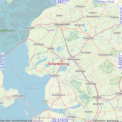
Scharsterbrug GPS coordinates[2]
52° 56' 38.904" North, 5° 46' 44.004" East
| Map corner | latitude | longitude |
|---|---|---|
| Upper-left | 53.36577°, | 5.07576° |
| Center: | 52.94414°, | 5.77889° |
| Lower-right: | 52.51836°, | 6.48201° |
| Map W x H: | 94.2×94.2 km | = 58.5×58.5mi |
| max Lat: | 53.48025° ⇑16.2% North |
| Scharsterbrug: | 52.94414° |
| min Lat: | ⇓83.8% South 50.76917° |
| min Long | Scharsterbrug | max Long |
| 3.38611° | 5.77889° | 7.16528° |
| W 56.3%⇐ | ⇒43.7% E |
Elevation
Elevation of Scharsterbrug is 1 m = 3 ft, and this is 14 m = 46 ft below average elevation for this country.
| Max E: |
203 m = 666 ft | 83.9% |
| Avg. | 15 m = 49 ft | |
| Scharsterbrug | 1 m = 3 ft | |
Min E: |
-6 m = -20 ft | 16.1% |
See also: Netherlands elevation on elevation.city.
Geographical zone
Scharsterbrug is located in North temperate zone (between Tropic of Cancer and the Arctic Circle). Distance of this North polar circle is 1514.3 km =940.9 mi to North.| Distance of | km | miles | from Scharsterbrug |
|---|---|---|---|
| North Pole | 4120.2 | 2560.2 | to North |
| Arctic Circle | 1514.3 | 940.9 | to North |
| Tropic Cancer | 3280.9 | 2038.7 | to South |
| Equator | 5886.8 | 3657.9 | to South |


Nearby cities:
15 places around Scharsterbrug: (largest is in red/bold)
• De Greiden
9 km =5.6 mi,  86°
86°
• Echtenerbrug
8.6 km =5.3 mi,  160°
160°
• Haskerhorne
3.5 km =2.2 mi,  72°
72°
• Heerenveen
9.5 km =5.9 mi,  79°
79°
• Hommerts
9.5 km =5.9 mi,  294°
294°
• Joure
2.9 km =1.8 mi,  33°
33°
• Langweer
4.1 km =2.5 mi, 292°
• Oppenhuizen
9.4 km =5.8 mi,  323°
323°
• Oudehaske
6.3 km =3.9 mi, 76°
• Rotsterhaule
5.6 km =3.5 mi,  119°
119°
• Rottum
7.8 km =4.8 mi,  96°
96°
• Sint Nicolaasga
3.4 km =2.1 mi,  226°
226°
• Sintjohannesga
5.3 km =3.3 mi,  105°
105°
• Terherne
9.9 km =6.2 mi,  1°
1°
• Woudsend
10.1 km =6.3 mi,  269°
269°
Sources, notices
• [Note1] Compared only with cities in Netherlands existing in our database
• [Src1] Map data: © OpenStreetMap contributors (CC-BY-SA)
• [Src2] Other city data from geonames.org with taken over terms of usage.
• [Src3] Geographical zone / Annual Mean Temperature by Robert A. Rohde @ Wikipedia
