Sintjohannesga geodata
Sintjohannesga (Friesland) is a populated place; located in Netherlands in Europe/Amsterdam (GMT+2) time zone. With population of 1,290 people, there are 1244 cities with bigger population in this country. Compared to other cities in Netherlands, 83.3% of cities are located further ↓South; 61.4% of cities are located further ←West and 96.1% of cities have higher elevation than Sintjohannesga. Note1


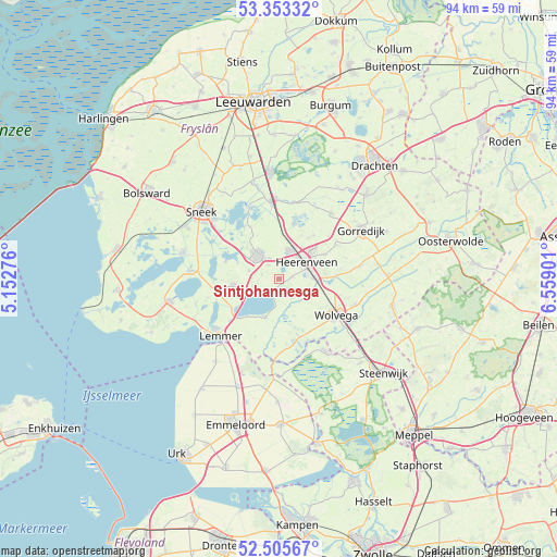
Sintjohannesga GPS coordinates[2]
52° 55' 53.652" North, 5° 51' 21.168" East
| Map corner | latitude | longitude |
|---|---|---|
| Upper-left | 53.35332°, | 5.15276° |
| Center: | 52.93157°, | 5.85588° |
| Lower-right: | 52.50567°, | 6.55901° |
| Map W x H: | 94.2×94.2 km | = 58.5×58.5mi |
| max Lat: | 53.48025° ⇑16.7% North |
| Sintjohannesga: | 52.93157° |
| min Lat: | ⇓83.3% South 50.76917° |
| min Long | Sintjohannesga | max Long |
| 3.38611° | 5.85588° | 7.16528° |
| W 61.4%⇐ | ⇒38.6% E |
Elevation
Elevation of Sintjohannesga is -1 m = -3 ft, and this is 16 m = 52 ft below average elevation for this country.
| Max E: |
203 m = 666 ft | 96.1% |
| Avg. | 15 m = 49 ft | |
| Sintjohannesga | -1 m = -3 ft | |
Min E: |
-6 m = -20 ft | 3.9% |
See also: Netherlands elevation on elevation.city.
Geographical zone
Sintjohannesga is located in North temperate zone (between Tropic of Cancer and the Arctic Circle). Distance of this North polar circle is 1515.7 km =941.8 mi to North.| Distance of | km | miles | from Sintjohannesga |
|---|---|---|---|
| North Pole | 4121.6 | 2561 | to North |
| Arctic Circle | 1515.7 | 941.8 | to North |
| Tropic Cancer | 3279.5 | 2037.8 | to South |
| Equator | 5885.4 | 3657 | to South |


Nearby cities:
15 places around Sintjohannesga: (largest is in red/bold)
• De Greiden
4.4 km =2.7 mi,  62°
62°
• De Knipe
8.7 km =5.4 mi, 62°
• Echtenerbrug
7.1 km =4.4 mi,  199°
199°
• Haskerhorne
3 km =1.9 mi,  323°
323°
• Heerenveen
5.2 km =3.2 mi,  53°
53°
• Joure
5.2 km =3.2 mi, 316°
• Langweer
9.5 km =5.9 mi,  288°
288°
• Oranjewoud
6.5 km =4 mi,  75°
75°
• Oudehaske
3 km =1.9 mi,  19°
19°
• Oudeschoot
6.7 km =4.2 mi,  88°
88°
• Rotsterhaule
1.4 km =0.9 mi,  191°
191°
• Rottum
2.6 km =1.6 mi, 77°
• Scharsterbrug
5.3 km =3.3 mi, 285°
• Sint Nicolaasga
7.7 km =4.8 mi,  262°
262°
• Tjalleberd
9.4 km =5.8 mi,  39°
39°
Sources, notices
• [Note1] Compared only with cities in Netherlands existing in our database
• [Src1] Map data: © OpenStreetMap contributors (CC-BY-SA)
• [Src2] Other city data from geonames.org with taken over terms of usage.
• [Src3] Geographical zone / Annual Mean Temperature by Robert A. Rohde @ Wikipedia
