Sas van Gent geodata
Sas van Gent (Zeeland) is a populated place; located in Netherlands in Europe/Amsterdam (GMT+2) time zone. With population of 3,856 people, there are 611 cities with bigger population in this country. Compared to other cities in Netherlands, 91.1% of cities are located further ↑North; 97.9% of cities are located further →East and 54.1% of cities have higher elevation than Sas van Gent. Note1


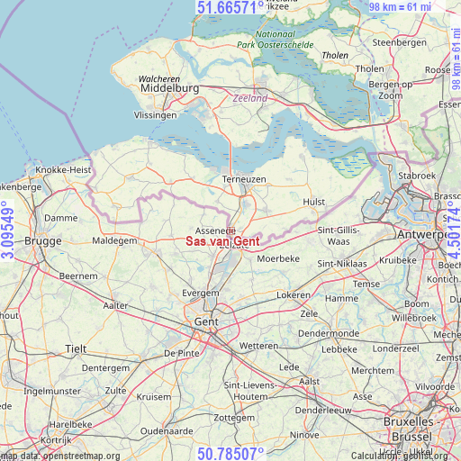
Sas van Gent GPS coordinates[2]
51° 13' 39" North, 3° 47' 54.996" East
| Map corner | latitude | longitude |
|---|---|---|
| Upper-left | 51.66571°, | 3.09549° |
| Center: | 51.2275°, | 3.79861° |
| Lower-right: | 50.78507°, | 4.50174° |
| Map W x H: | 97.9×97.9 km | = 60.8×60.8mi |
| max Lat: | 53.48025° ⇑91.1% North |
| Sas van Gent: | 51.2275° |
| min Lat: | ⇓8.9% South 50.76917° |
| min Long | Sas van Gent | max Long |
| 3.38611° | 3.79861° | 7.16528° |
| W 2.1%⇐ | ⇒97.9% E |
Elevation
Elevation of Sas van Gent is 5 m = 16 ft, and this is 10 m = 33 ft below average elevation for this country.
| Max E: |
203 m = 666 ft | 54.1% |
| Avg. | 15 m = 49 ft | |
| Sas van Gent | 5 m = 16 ft | |
Min E: |
-6 m = -20 ft | 45.9% |
See also: Netherlands elevation on elevation.city.
Geographical zone
Sas van Gent is located in North temperate zone (between Tropic of Cancer and the Arctic Circle). Distance of this North polar circle is 1705.2 km =1059.6 mi to North.| Distance of | km | miles | from Sas van Gent |
|---|---|---|---|
| North Pole | 4311.1 | 2678.8 | to North |
| Arctic Circle | 1705.2 | 1059.6 | to North |
| Tropic Cancer | 3090 | 1920 | to South |
| Equator | 5696 | 3539.3 | to South |


Nearby cities:
15 places around Sas van Gent: (largest is in red/bold)
• Axel
8.8 km =5.5 mi,  60°
60°
• Borssele
22.2 km =13.8 mi,  348°
348°
• Driewegen
21.2 km =13.2 mi,  0°
0°
• Hoofdplaat
18.4 km =11.4 mi,  329°
329°
• Hulst
18.6 km =11.6 mi,  71°
71°
• IJzendijke
16.4 km =10.2 mi,  309°
309°
• Koewacht
12.2 km =7.6 mi,  89°
89°
• Oostburg
24.2 km =15 mi,  296°
296°
• Othene
12.3 km =7.6 mi,  20°
20°
• Schoondijke
22 km =13.7 mi, 309°
• Sluiskil
6.2 km =3.9 mi, 24°
• Terneuzen
12.2 km =7.6 mi,  9°
9°
• Westdorpe
2 km =1.2 mi, 73°
• Zaamslag
12.3 km =7.6 mi,  39°
39°
• Zuiddorpe
7.4 km =4.6 mi,  83°
83°
Sources, notices
• [Note1] Compared only with cities in Netherlands existing in our database
• [Src1] Map data: © OpenStreetMap contributors (CC-BY-SA)
• [Src2] Other city data from geonames.org with taken over terms of usage.
• [Src3] Geographical zone / Annual Mean Temperature by Robert A. Rohde @ Wikipedia
