Zaamslag geodata
Zaamslag (Zeeland) is a populated place; located in Netherlands in Europe/Amsterdam (GMT+2) time zone. With population of 2,980 people, there are 760 cities with bigger population in this country. Compared to other cities in Netherlands, 89% of cities are located further ↑North; 97.1% of cities are located further →East and 58.8% of cities have higher elevation than Zaamslag. Note1


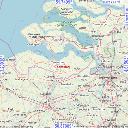
Zaamslag GPS coordinates[2]
51° 18' 45" North, 3° 54' 45" East
| Map corner | latitude | longitude |
|---|---|---|
| Upper-left | 51.7499°, | 3.20938° |
| Center: | 51.3125°, | 3.9125° |
| Lower-right: | 50.87089°, | 4.61563° |
| Map W x H: | 97.7×97.7 km | = 60.7×60.7mi |
| max Lat: | 53.48025° ⇑89% North |
| Zaamslag: | 51.3125° |
| min Lat: | ⇓11% South 50.76917° |
| min Long | Zaamslag | max Long |
| 3.38611° | 3.9125° | 7.16528° |
| W 2.9%⇐ | ⇒97.1% E |
Elevation
Elevation of Zaamslag is 4 m = 13 ft, and this is 11 m = 36 ft below average elevation for this country.
| Max E: |
203 m = 666 ft | 58.8% |
| Avg. | 15 m = 49 ft | |
| Zaamslag | 4 m = 13 ft | |
Min E: |
-6 m = -20 ft | 41.2% |
See also: Netherlands elevation on elevation.city.
Geographical zone
Zaamslag is located in North temperate zone (between Tropic of Cancer and the Arctic Circle). Distance of this North polar circle is 1695.8 km =1053.7 mi to North.| Distance of | km | miles | from Zaamslag |
|---|---|---|---|
| North Pole | 4301.6 | 2672.9 | to North |
| Arctic Circle | 1695.8 | 1053.7 | to North |
| Tropic Cancer | 3099.5 | 1925.9 | to South |
| Equator | 5705.4 | 3545.2 | to South |


Nearby cities:
15 places around Zaamslag: (largest is in red/bold)
• Axel
5.1 km =3.2 mi,  183°
183°
• Borssele
17.4 km =10.8 mi,  314°
314°
• Driewegen
14 km =8.7 mi,  327°
327°
• Hoofdplaat
18.5 km =11.5 mi,  289°
289°
• Hulst
10.4 km =6.5 mi,  110°
110°
• Kapelle
19.6 km =12.2 mi,  9°
9°
• Koewacht
10.3 km =6.4 mi,  155°
155°
• Oostdijk
18.6 km =11.6 mi,  38°
38°
• Othene
4.2 km =2.6 mi,  299°
299°
• Sas van Gent
12.3 km =7.6 mi,  219°
219°
• Sluiskil
6.5 km =4 mi,  234°
234°
• Terneuzen
6.4 km =4 mi, 293°
• Waarde
15.9 km =9.9 mi, 42°
• Westdorpe
10.7 km =6.6 mi,  213°
213°
• Zuiddorpe
8.6 km =5.3 mi, 183°
Sources, notices
• [Note1] Compared only with cities in Netherlands existing in our database
• [Src1] Map data: © OpenStreetMap contributors (CC-BY-SA)
• [Src2] Other city data from geonames.org with taken over terms of usage.
• [Src3] Geographical zone / Annual Mean Temperature by Robert A. Rohde @ Wikipedia
