Othene geodata
Othene (Zeeland) is a section of populated place; located in Netherlands in Europe/Amsterdam (GMT+2) time zone. With population of 3,325 people, there are 708 cities with bigger population in this country. Compared to other cities in Netherlands, 88.6% of cities are located further ↑North; 97.4% of cities are located further →East and 74.9% of cities have higher elevation than Othene. Note1


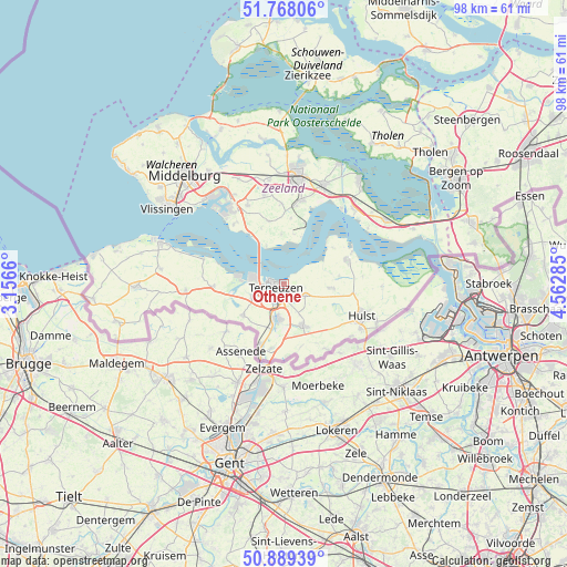
Othene GPS coordinates[2]
51° 19' 50.988" North, 3° 51' 34.992" East
| Map corner | latitude | longitude |
|---|---|---|
| Upper-left | 51.76806°, | 3.1566° |
| Center: | 51.33083°, | 3.85972° |
| Lower-right: | 50.88939°, | 4.56285° |
| Map W x H: | 97.7×97.7 km | = 60.7×60.7mi |
| max Lat: | 53.48025° ⇑88.6% North |
| Othene: | 51.33083° |
| min Lat: | ⇓11.4% South 50.76917° |
| min Long | Othene | max Long |
| 3.38611° | 3.85972° | 7.16528° |
| W 2.6%⇐ | ⇒97.4% E |
Elevation
Elevation of Othene is 2 m = 7 ft, and this is 13 m = 43 ft below average elevation for this country.
| Max E: |
203 m = 666 ft | 74.9% |
| Avg. | 15 m = 49 ft | |
| Othene | 2 m = 7 ft | |
Min E: |
-6 m = -20 ft | 25.1% |
See also: Netherlands elevation on elevation.city.
Geographical zone
Othene is located in North temperate zone (between Tropic of Cancer and the Arctic Circle). Distance of this North polar circle is 1693.7 km =1052.4 mi to North.| Distance of | km | miles | from Othene |
|---|---|---|---|
| North Pole | 4299.6 | 2671.6 | to North |
| Arctic Circle | 1693.7 | 1052.4 | to North |
| Tropic Cancer | 3101.5 | 1927.2 | to South |
| Equator | 5707.5 | 3546.5 | to South |


Nearby cities:
15 places around Othene: (largest is in red/bold)
• Axel
7.9 km =4.9 mi,  154°
154°
• Borssele
13.5 km =8.4 mi,  319°
319°
• Driewegen
10.5 km =6.5 mi,  337°
337°
• Hoofdplaat
14.3 km =8.9 mi,  287°
287°
• Hulst
14.6 km =9.1 mi,  112°
112°
• IJzendijke
16.9 km =10.5 mi,  266°
266°
• Kapelle
18.6 km =11.6 mi,  21°
21°
• Koewacht
13.9 km =8.6 mi, 145°
• Sas van Gent
12.3 km =7.6 mi,  200°
200°
• Sluiskil
6.1 km =3.8 mi, 195°
• Terneuzen
2.3 km =1.4 mi,  284°
284°
• Waarde
17.4 km =10.8 mi,  56°
56°
• Westdorpe
11.2 km =7 mi,  191°
191°
• Zaamslag
4.2 km =2.6 mi,  119°
119°
• Zuiddorpe
11.1 km =6.9 mi,  163°
163°
Sources, notices
• [Note1] Compared only with cities in Netherlands existing in our database
• [Src1] Map data: © OpenStreetMap contributors (CC-BY-SA)
• [Src2] Other city data from geonames.org with taken over terms of usage.
• [Src3] Geographical zone / Annual Mean Temperature by Robert A. Rohde @ Wikipedia
