Meerwijck geodata
Meerwijck (Groningen) is a populated place; located in Netherlands in Europe/Amsterdam (GMT+2) time zone. With population of 1,000 people, there are 1401 cities with bigger population in this country. Compared to other cities in Netherlands, 90.5% of cities are located further ↓South; 93.6% of cities are located further ←West and 91.3% of cities have higher elevation than Meerwijck. Note1


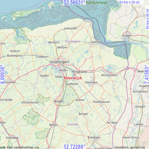
Meerwijck GPS coordinates[2]
53° 8' 48.012" North, 6° 42' 45" East
| Map corner | latitude | longitude |
|---|---|---|
| Upper-left | 53.56631°, | 6.00938° |
| Center: | 53.14667°, | 6.7125° |
| Lower-right: | 52.72288°, | 7.41563° |
| Map W x H: | 93.8×93.8 km | = 58.3×58.3mi |
| max Lat: | 53.48025° ⇑9.5% North |
| Meerwijck: | 53.14667° |
| min Lat: | ⇓90.5% South 50.76917° |
| min Long | Meerwijck | max Long |
| 3.38611° | 6.7125° | 7.16528° |
| W 93.6%⇐ | ⇒6.4% E |
Elevation
Elevation of Meerwijck is 0 m = 0 ft, and this is 15 m = 49 ft below average elevation for this country.
| Max E: |
203 m = 666 ft | 91.3% |
| Avg. | 15 m = 49 ft | |
| Meerwijck | 0 m = 0 ft | |
Min E: |
-6 m = -20 ft | 8.7% |
See also: Netherlands elevation on elevation.city.
Geographical zone
Meerwijck is located in North temperate zone (between Tropic of Cancer and the Arctic Circle). Distance of this North polar circle is 1491.8 km =927 mi to North.| Distance of | km | miles | from Meerwijck |
|---|---|---|---|
| North Pole | 4097.7 | 2546.2 | to North |
| Arctic Circle | 1491.8 | 927 | to North |
| Tropic Cancer | 3303.4 | 2052.6 | to South |
| Equator | 5909.4 | 3671.9 | to South |


Nearby cities:
15 places around Meerwijck: (largest is in red/bold)
• Engelbert
8.1 km =5 mi,  327°
327°
• Foxhol
2.4 km =1.5 mi,  15°
15°
• Froombosch
7 km =4.3 mi,  40°
40°
• Glimmen
5.6 km =3.5 mi,  261°
261°
• Haren
7.4 km =4.6 mi,  292°
292°
• Harkstede
7.5 km =4.7 mi,  352°
352°
• Hoogezand
3.6 km =2.2 mi,  62°
62°
• Kiel-Windeweer
5.8 km =3.6 mi,  130°
130°
• Kolham
4.5 km =2.8 mi,  28°
28°
• Martenshoek
2.2 km =1.4 mi, 33°
• Sappemeer
5.5 km =3.4 mi,  69°
69°
• Scharmer
6.5 km =4 mi,  355°
355°
• Schipborg
8.4 km =5.2 mi,  199°
199°
• Westlaren
7.6 km =4.7 mi, 204°
• Zuidlaren
6.2 km =3.9 mi, 199°
Sources, notices
• [Note1] Compared only with cities in Netherlands existing in our database
• [Src1] Map data: © OpenStreetMap contributors (CC-BY-SA)
• [Src2] Other city data from geonames.org with taken over terms of usage.
• [Src3] Geographical zone / Annual Mean Temperature by Robert A. Rohde @ Wikipedia
