Martenshoek geodata
Martenshoek (Groningen) is a populated place; located in Netherlands in Europe/Amsterdam (GMT+2) time zone. With population of 610 people, there are 1710 cities with bigger population in this country. Compared to other cities in Netherlands, 91.5% of cities are located further ↓South; 94.1% of cities are located further ←West and 91.3% of cities have higher elevation than Martenshoek. Note1


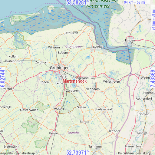
Martenshoek GPS coordinates[2]
53° 9' 47.988" North, 6° 43' 50.016" East
| Map corner | latitude | longitude |
|---|---|---|
| Upper-left | 53.58281°, | 6.02744° |
| Center: | 53.16333°, | 6.73056° |
| Lower-right: | 52.73971°, | 7.43369° |
| Map W x H: | 93.7×93.7 km | = 58.2×58.2mi |
| max Lat: | 53.48025° ⇑8.5% North |
| Martenshoek: | 53.16333° |
| min Lat: | ⇓91.5% South 50.76917° |
| min Long | Martenshoek | max Long |
| 3.38611° | 6.73056° | 7.16528° |
| W 94.1%⇐ | ⇒5.9% E |
Elevation
Elevation of Martenshoek is 0 m = 0 ft, and this is 15 m = 49 ft below average elevation for this country.
| Max E: |
203 m = 666 ft | 91.3% |
| Avg. | 15 m = 49 ft | |
| Martenshoek | 0 m = 0 ft | |
Min E: |
-6 m = -20 ft | 8.7% |
See also: Netherlands elevation on elevation.city.
Geographical zone
Martenshoek is located in North temperate zone (between Tropic of Cancer and the Arctic Circle). Distance of this North polar circle is 1490 km =925.8 mi to North.| Distance of | km | miles | from Martenshoek |
|---|---|---|---|
| North Pole | 4095.9 | 2545.1 | to North |
| Arctic Circle | 1490 | 925.8 | to North |
| Tropic Cancer | 3305.3 | 2053.8 | to South |
| Equator | 5911.2 | 3673 | to South |


Nearby cities:
15 places around Martenshoek: (largest is in red/bold)
• Engelbert
7.5 km =4.7 mi,  312°
312°
• Foxhol
0.7 km =0.4 mi, 307°
• Froombosch
4.8 km =3 mi,  44°
44°
• Glimmen
7.3 km =4.5 mi,  248°
248°
• Haren
8.1 km =5 mi,  276°
276°
• Harkstede
6 km =3.7 mi,  339°
339°
• Hoogezand
2 km =1.2 mi,  95°
95°
• Kiel-Windeweer
6.5 km =4 mi,  150°
150°
• Kolham
2.3 km =1.4 mi,  23°
23°
• Meerwijck
2.2 km =1.4 mi,  213°
213°
• Sappemeer
4 km =2.5 mi,  88°
88°
• Scharmer
4.9 km =3 mi, 340°
• Slochteren
8.1 km =5 mi, 37°
• Zuidbroek
8.7 km =5.4 mi, 90°
• Zuidlaren
8.3 km =5.2 mi,  202°
202°
Sources, notices
• [Note1] Compared only with cities in Netherlands existing in our database
• [Src1] Map data: © OpenStreetMap contributors (CC-BY-SA)
• [Src2] Other city data from geonames.org with taken over terms of usage.
• [Src3] Geographical zone / Annual Mean Temperature by Robert A. Rohde @ Wikipedia
