Rockanje geodata
Rockanje (South Holland) is a populated place; located in Netherlands in Europe/Amsterdam (GMT+2) time zone. With population of 1,275 people, there are 1250 cities with bigger population in this country. Compared to other cities in Netherlands, 60.3% of cities are located further ↑North; 96.1% of cities are located further →East and 96.1% of cities have higher elevation than Rockanje. Note1


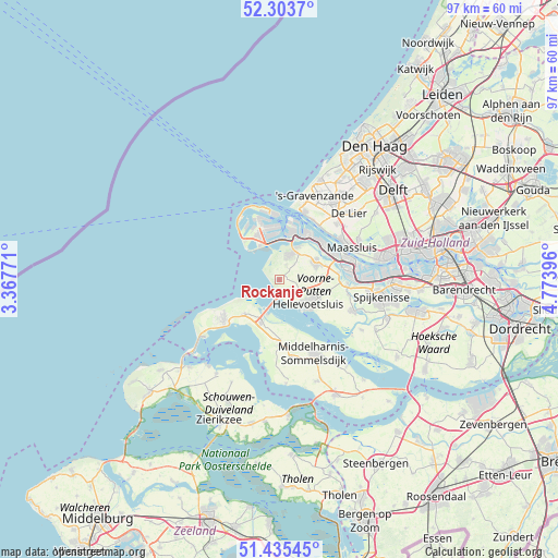
Rockanje GPS coordinates[2]
51° 52' 18.012" North, 4° 4' 14.988" East
| Map corner | latitude | longitude |
|---|---|---|
| Upper-left | 52.3037°, | 3.36771° |
| Center: | 51.87167°, | 4.07083° |
| Lower-right: | 51.43545°, | 4.77396° |
| Map W x H: | 96.5×96.5 km | = 60×60mi |
| max Lat: | 53.48025° ⇑60.3% North |
| Rockanje: | 51.87167° |
| min Lat: | ⇓39.7% South 50.76917° |
| min Long | Rockanje | max Long |
| 3.38611° | 4.07083° | 7.16528° |
| W 3.9%⇐ | ⇒96.1% E |
Elevation
Elevation of Rockanje is -1 m = -3 ft, and this is 16 m = 52 ft below average elevation for this country.
| Max E: |
203 m = 666 ft | 96.1% |
| Avg. | 15 m = 49 ft | |
| Rockanje | -1 m = -3 ft | |
Min E: |
-6 m = -20 ft | 3.9% |
See also: Netherlands elevation on elevation.city.
Geographical zone
Rockanje is located in North temperate zone (between Tropic of Cancer and the Arctic Circle). Distance of this North polar circle is 1633.6 km =1015.1 mi to North.| Distance of | km | miles | from Rockanje |
|---|---|---|---|
| North Pole | 4239.5 | 2634.3 | to North |
| Arctic Circle | 1633.6 | 1015.1 | to North |
| Tropic Cancer | 3161.7 | 1964.6 | to South |
| Equator | 5767.6 | 3583.8 | to South |


Nearby cities:
15 places around Rockanje: (largest is in red/bold)
• Brielle
7.1 km =4.4 mi,  62°
62°
• Dirksland
13.8 km =8.6 mi,  171°
171°
• Goedereede
8.6 km =5.3 mi,  225°
225°
• Hellevoetsluis
6 km =3.7 mi,  134°
134°
• Hoek van Holland
12.5 km =7.8 mi,  20°
20°
• Maasdijk
13.8 km =8.6 mi,  45°
45°
• Maassluis
13.6 km =8.5 mi, 64°
• Nieuwenhoorn
5.3 km =3.3 mi,  111°
111°
• Oostvoorne
4.9 km =3 mi, 22°
• Ouddorp
11.5 km =7.1 mi, 234°
• Rozenburg
12.7 km =7.9 mi,  73°
73°
• Rugge
6.4 km =4 mi, 61°
• Stuifakker
1.5 km =0.9 mi,  337°
337°
• Vierpolders
7.5 km =4.7 mi,  83°
83°
• Zwartewaal
10.4 km =6.5 mi, 82°
Sources, notices
• [Note1] Compared only with cities in Netherlands existing in our database
• [Src1] Map data: © OpenStreetMap contributors (CC-BY-SA)
• [Src2] Other city data from geonames.org with taken over terms of usage.
• [Src3] Geographical zone / Annual Mean Temperature by Robert A. Rohde @ Wikipedia
