Maassluis geodata
Maassluis (South Holland) is a populated place; located in Netherlands in Europe/Amsterdam (GMT+2) time zone. With population of 32,780 people, there are 98 cities with bigger population in this country. Compared to other cities in Netherlands, 56% of cities are located further ↑North; 94.4% of cities are located further →East and 74.9% of cities have higher elevation than Maassluis. Note1


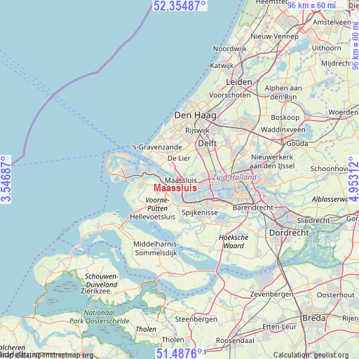
Maassluis GPS coordinates[2]
51° 55' 23.988" North, 4° 15' 0" East
| Map corner | latitude | longitude |
|---|---|---|
| Upper-left | 52.35487°, | 3.54687° |
| Center: | 51.92333°, | 4.25° |
| Lower-right: | 51.4876°, | 4.95312° |
| Map W x H: | 96.4×96.4 km | = 59.9×59.9mi |
| max Lat: | 53.48025° ⇑56% North |
| Maassluis: | 51.92333° |
| min Lat: | ⇓44% South 50.76917° |
| min Long | Maassluis | max Long |
| 3.38611° | 4.25° | 7.16528° |
| W 5.6%⇐ | ⇒94.4% E |
Elevation
Elevation of Maassluis is 2 m = 7 ft, and this is 13 m = 43 ft below average elevation for this country.
| Max E: |
203 m = 666 ft | 74.9% |
| Avg. | 15 m = 49 ft | |
| Maassluis | 2 m = 7 ft | |
Min E: |
-6 m = -20 ft | 25.1% |
See also: Netherlands elevation on elevation.city.
Geographical zone
Maassluis is located in North temperate zone (between Tropic of Cancer and the Arctic Circle). Distance of this North polar circle is 1627.8 km =1011.5 mi to North.| Distance of | km | miles | from Maassluis |
|---|---|---|---|
| North Pole | 4233.7 | 2630.7 | to North |
| Arctic Circle | 1627.8 | 1011.5 | to North |
| Tropic Cancer | 3167.4 | 1968.1 | to South |
| Equator | 5773.3 | 3587.4 | to South |


Nearby cities:
15 places around Maassluis: (largest is in red/bold)
• Brielle
6.5 km =4 mi,  248°
248°
• De Lier
5.7 km =3.5 mi,  359°
359°
• Heenweg
8 km =5 mi,  323°
323°
• Honselersdijk
9.4 km =5.8 mi,  349°
349°
• Maasdijk
4.7 km =2.9 mi,  328°
328°
• Maasland
1.9 km =1.2 mi,  51°
51°
• Naaldwijk
8.3 km =5.2 mi,  340°
340°
• Rozenburg
2.1 km =1.3 mi,  182°
182°
• Rugge
7.2 km =4.5 mi, 248°
• Schiedam
9.5 km =5.9 mi,  92°
92°
• Schipluiden
7.3 km =4.5 mi,  36°
36°
• Tuindorp
8.8 km =5.5 mi,  84°
84°
• Vierpolders
6.9 km =4.3 mi,  224°
224°
• Vlaardingen
6.4 km =4 mi,  100°
100°
• Zwartewaal
4.9 km =3 mi,  204°
204°
Sources, notices
• [Note1] Compared only with cities in Netherlands existing in our database
• [Src1] Map data: © OpenStreetMap contributors (CC-BY-SA)
• [Src2] Other city data from geonames.org with taken over terms of usage.
• [Src3] Geographical zone / Annual Mean Temperature by Robert A. Rohde @ Wikipedia
