Zwartewaal geodata
Zwartewaal (South Holland) is a populated place; located in Netherlands in Europe/Amsterdam (GMT+2) time zone. With population of 615 people, there are 1704 cities with bigger population in this country. Compared to other cities in Netherlands, 59.3% of cities are located further ↑North; 94.8% of cities are located further →East and 96.1% of cities have higher elevation than Zwartewaal. Note1


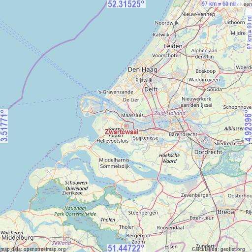
Zwartewaal GPS coordinates[2]
51° 52' 59.988" North, 4° 13' 14.988" East
| Map corner | latitude | longitude |
|---|---|---|
| Upper-left | 52.31525°, | 3.51771° |
| Center: | 51.88333°, | 4.22083° |
| Lower-right: | 51.44722°, | 4.92396° |
| Map W x H: | 96.5×96.5 km | = 60×60mi |
| max Lat: | 53.48025° ⇑59.3% North |
| Zwartewaal: | 51.88333° |
| min Lat: | ⇓40.7% South 50.76917° |
| min Long | Zwartewaal | max Long |
| 3.38611° | 4.22083° | 7.16528° |
| W 5.2%⇐ | ⇒94.8% E |
Elevation
Elevation of Zwartewaal is -1 m = -3 ft, and this is 16 m = 52 ft below average elevation for this country.
| Max E: |
203 m = 666 ft | 96.1% |
| Avg. | 15 m = 49 ft | |
| Zwartewaal | -1 m = -3 ft | |
Min E: |
-6 m = -20 ft | 3.9% |
See also: Netherlands elevation on elevation.city.
Geographical zone
Zwartewaal is located in North temperate zone (between Tropic of Cancer and the Arctic Circle). Distance of this North polar circle is 1632.3 km =1014.3 mi to North.| Distance of | km | miles | from Zwartewaal |
|---|---|---|---|
| North Pole | 4238.2 | 2633.5 | to North |
| Arctic Circle | 1632.3 | 1014.3 | to North |
| Tropic Cancer | 3163 | 1965.4 | to South |
| Equator | 5768.9 | 3584.6 | to South |


Nearby cities:
15 places around Zwartewaal: (largest is in red/bold)
• Brielle
4.5 km =2.8 mi,  296°
296°
• De Lier
10.4 km =6.5 mi,  10°
10°
• Goudswaard
10.6 km =6.6 mi,  158°
158°
• Hellevoetsluis
8.2 km =5.1 mi,  227°
227°
• Maasdijk
8.4 km =5.2 mi,  356°
356°
• Maasland
6.7 km =4.2 mi,  31°
31°
• Maassluis
4.9 km =3 mi,  24°
24°
• Nieuwenhoorn
6.2 km =3.9 mi,  238°
238°
• Oostvoorne
9 km =5.6 mi,  291°
291°
• Rockanje
10.4 km =6.5 mi,  262°
262°
• Rozenburg
3 km =1.9 mi,  39°
39°
• Rugge
5 km =3.1 mi, 290°
• Spijkenisse
8.6 km =5.3 mi,  119°
119°
• Vierpolders
2.9 km =1.8 mi, 260°
• Vlaardingen
8.9 km =5.5 mi,  68°
68°
Sources, notices
• [Note1] Compared only with cities in Netherlands existing in our database
• [Src1] Map data: © OpenStreetMap contributors (CC-BY-SA)
• [Src2] Other city data from geonames.org with taken over terms of usage.
• [Src3] Geographical zone / Annual Mean Temperature by Robert A. Rohde @ Wikipedia
