Heinenoord geodata
Heinenoord (South Holland) is a populated place; located in Netherlands in Europe/Amsterdam (GMT+2) time zone. With population of 610 people, there are 1710 cities with bigger population in this country. Compared to other cities in Netherlands, 62.7% of cities are located further ↑North; 90% of cities are located further →East and 83.9% of cities have higher elevation than Heinenoord. Note1


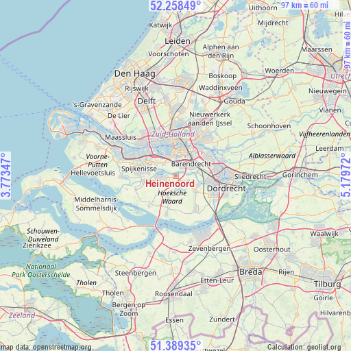
Heinenoord GPS coordinates[2]
51° 49' 33.672" North, 4° 28' 35.724" East
| Map corner | latitude | longitude |
|---|---|---|
| Upper-left | 52.25849°, | 3.77347° |
| Center: | 51.82602°, | 4.47659° |
| Lower-right: | 51.38935°, | 5.17972° |
| Map W x H: | 96.6×96.6 km | = 60×60mi |
| max Lat: | 53.48025° ⇑62.7% North |
| Heinenoord: | 51.82602° |
| min Lat: | ⇓37.3% South 50.76917° |
| min Long | Heinenoord | max Long |
| 3.38611° | 4.47659° | 7.16528° |
| W 10%⇐ | ⇒90% E |
Elevation
Elevation of Heinenoord is 1 m = 3 ft, and this is 14 m = 46 ft below average elevation for this country.
| Max E: |
203 m = 666 ft | 83.9% |
| Avg. | 15 m = 49 ft | |
| Heinenoord | 1 m = 3 ft | |
Min E: |
-6 m = -20 ft | 16.1% |
See also: Netherlands elevation on elevation.city.
Geographical zone
Heinenoord is located in North temperate zone (between Tropic of Cancer and the Arctic Circle). Distance of this North polar circle is 1638.7 km =1018.2 mi to North.| Distance of | km | miles | from Heinenoord |
|---|---|---|---|
| North Pole | 4244.5 | 2637.4 | to North |
| Arctic Circle | 1638.7 | 1018.2 | to North |
| Tropic Cancer | 3156.6 | 1961.4 | to South |
| Equator | 5762.5 | 3580.7 | to South |


Nearby cities:
15 places around Heinenoord: (largest is in red/bold)
• Barendrecht
5.2 km =3.2 mi,  49°
49°
• Carnisse
7 km =4.3 mi,  0°
0°
• Groot IJsselmonde
8 km =5 mi,  38°
38°
• Heerjansdam
6.1 km =3.8 mi,  79°
79°
• Klaaswaal
6.6 km =4.1 mi,  198°
198°
• Lombardijen
6.2 km =3.9 mi,  30°
30°
• Maasdam
6.8 km =4.2 mi,  127°
127°
• Mijnsheerenland
3.3 km =2.1 mi,  167°
167°
• Oud-Beijerland
4.4 km =2.7 mi,  267°
267°
• Pendrecht
5.1 km =3.2 mi,  354°
354°
• Rhoon
5.1 km =3.2 mi,  313°
313°
• Smitshoek
3.3 km =2.1 mi,  7°
7°
• Vreewijk
7.1 km =4.4 mi,  24°
24°
• Westmaas
4.4 km =2.7 mi,  181°
181°
• Zuidwijk
5.5 km =3.4 mi, 6°
Sources, notices
• [Note1] Compared only with cities in Netherlands existing in our database
• [Src1] Map data: © OpenStreetMap contributors (CC-BY-SA)
• [Src2] Other city data from geonames.org with taken over terms of usage.
• [Src3] Geographical zone / Annual Mean Temperature by Robert A. Rohde @ Wikipedia
