Rhenen geodata
Rhenen (Utrecht) is a populated place; located in Netherlands in Europe/Amsterdam (GMT+2) time zone. With population of 18,061 people, there are 196 cities with bigger population in this country. Compared to other cities in Netherlands, 53.8% of cities are located further ↑North; 53.9% of cities are located further →East and 88.5% of cities have lower elevation than Rhenen. Note1


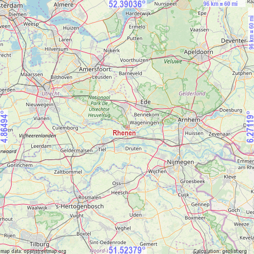
Rhenen GPS coordinates[2]
51° 57' 33.012" North, 5° 34' 5.016" East
| Map corner | latitude | longitude |
|---|---|---|
| Upper-left | 52.39036°, | 4.86494° |
| Center: | 51.95917°, | 5.56806° |
| Lower-right: | 51.52379°, | 6.27119° |
| Map W x H: | 96.4×96.4 km | = 59.9×59.9mi |
| max Lat: | 53.48025° ⇑53.8% North |
| Rhenen: | 51.95917° |
| min Lat: | ⇓46.2% South 50.76917° |
| min Long | Rhenen | max Long |
| 3.38611° | 5.56806° | 7.16528° |
| W 46.1%⇐ | ⇒53.9% E |
Elevation
Elevation of Rhenen is 31 m = 102 ft, and this is 16 m = 52 ft above average elevation for this country.
| Max E: |
203 m = 666 ft | 11.5% |
| Rhenen | 31 m 102 ft | |
| Avg. | 15 m = 49 ft | |
Min E: |
-6 m = -20 ft | 88.5% |
See also: Netherlands elevation on elevation.city.
Geographical zone
Rhenen is located in North temperate zone (between Tropic of Cancer and the Arctic Circle). Distance of this North polar circle is 1623.9 km =1009 mi to North.| Distance of | km | miles | from Rhenen |
|---|---|---|---|
| North Pole | 4229.7 | 2628.2 | to North |
| Arctic Circle | 1623.9 | 1009 | to North |
| Tropic Cancer | 3171.4 | 1970.6 | to South |
| Equator | 5777.3 | 3589.8 | to South |


Nearby cities:
15 places around Rhenen: (largest is in red/bold)
• Achterberg
2 km =1.2 mi,  41°
41°
• Amerongen
8.8 km =5.5 mi,  302°
302°
• Bennekom
8.6 km =5.3 mi,  59°
59°
• Druten
8.3 km =5.2 mi,  161°
161°
• Echteld
7.4 km =4.6 mi,  222°
222°
• Eck en Wiel
7.7 km =4.8 mi,  278°
278°
• IJzendoorn
6.4 km =4 mi,  201°
201°
• Ingen
5.7 km =3.5 mi,  270°
270°
• Kesteren
2.7 km =1.7 mi,  177°
177°
• Lienden
3.6 km =2.2 mi,  250°
250°
• Ochten
5.5 km =3.4 mi, 179°
• Opheusden
5.3 km =3.3 mi,  124°
124°
• Puiflijk
9.1 km =5.7 mi,  170°
170°
• Veenendaal
7.7 km =4.8 mi,  355°
355°
• Wageningen
6.9 km =4.3 mi,  79°
79°
Sources, notices
• [Note1] Compared only with cities in Netherlands existing in our database
• [Src1] Map data: © OpenStreetMap contributors (CC-BY-SA)
• [Src2] Other city data from geonames.org with taken over terms of usage.
• [Src3] Geographical zone / Annual Mean Temperature by Robert A. Rohde @ Wikipedia
