Amerongen geodata
Amerongen (Utrecht) is a populated place; located in Netherlands in Europe/Amsterdam (GMT+2) time zone. With population of 5,085 people, there are 477 cities with bigger population in this country. Compared to other cities in Netherlands, 51% of cities are located further ↑North; 58.5% of cities are located further →East and 77.1% of cities have lower elevation than Amerongen. Note1


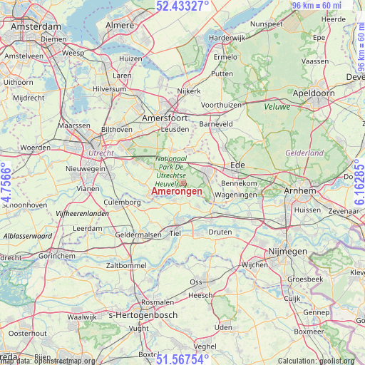
Amerongen GPS coordinates[2]
52° 0' 9" North, 5° 27' 34.992" East
| Map corner | latitude | longitude |
|---|---|---|
| Upper-left | 52.43327°, | 4.7566° |
| Center: | 52.0025°, | 5.45972° |
| Lower-right: | 51.56754°, | 6.16285° |
| Map W x H: | 96.3×96.3 km | = 59.8×59.8mi |
| max Lat: | 53.48025° ⇑51% North |
| Amerongen: | 52.0025° |
| min Lat: | ⇓49% South 50.76917° |
| min Long | Amerongen | max Long |
| 3.38611° | 5.45972° | 7.16528° |
| W 41.5%⇐ | ⇒58.5% E |
Elevation
Elevation of Amerongen is 19 m = 62 ft, and this is 4 m = 13 ft above average elevation for this country.
| Max E: |
203 m = 666 ft | 22.9% |
| Amerongen | 19 m 62 ft | |
| Avg. | 15 m = 49 ft | |
Min E: |
-6 m = -20 ft | 77.1% |
See also: Netherlands elevation on elevation.city.
Geographical zone
Amerongen is located in North temperate zone (between Tropic of Cancer and the Arctic Circle). Distance of this North polar circle is 1619 km =1006 mi to North.| Distance of | km | miles | from Amerongen |
|---|---|---|---|
| North Pole | 4224.9 | 2625.2 | to North |
| Arctic Circle | 1619 | 1006 | to North |
| Tropic Cancer | 3176.2 | 1973.6 | to South |
| Equator | 5782.1 | 3592.8 | to South |


Nearby cities:
15 places around Amerongen: (largest is in red/bold)
• De Klomp
9.1 km =5.7 mi,  57°
57°
• Doorn
8.5 km =5.3 mi,  293°
293°
• Eck en Wiel
3.7 km =2.3 mi,  182°
182°
• Ingen
5.1 km =3.2 mi,  160°
160°
• Leersum
2.4 km =1.5 mi,  295°
295°
• Lienden
7.2 km =4.5 mi,  146°
146°
• Maarn
9.2 km =5.7 mi,  318°
318°
• Maarsbergen
7.2 km =4.5 mi,  329°
329°
• Maurik
5.3 km =3.3 mi,  208°
208°
• Overberg
4.8 km =3 mi,  29°
29°
• Rhenen
8.8 km =5.5 mi,  122°
122°
• Scherpenzeel
8.8 km =5.5 mi,  13°
13°
• Veenendaal
7.4 km =4.6 mi,  66°
66°
• Wijk bij Duurstede
8.7 km =5.4 mi,  248°
248°
• Woudenberg
9.2 km =5.7 mi,  341°
341°
Sources, notices
• [Note1] Compared only with cities in Netherlands existing in our database
• [Src1] Map data: © OpenStreetMap contributors (CC-BY-SA)
• [Src2] Other city data from geonames.org with taken over terms of usage.
• [Src3] Geographical zone / Annual Mean Temperature by Robert A. Rohde @ Wikipedia
