Achterberg geodata
Achterberg (Utrecht) is a populated place; located in Netherlands in Europe/Amsterdam (GMT+2) time zone. With population of 750 people, there are 1566 cities with bigger population in this country. Compared to other cities in Netherlands, 53.1% of cities are located further ↑North; 52.9% of cities are located further →East and 62% of cities have lower elevation than Achterberg. Note1


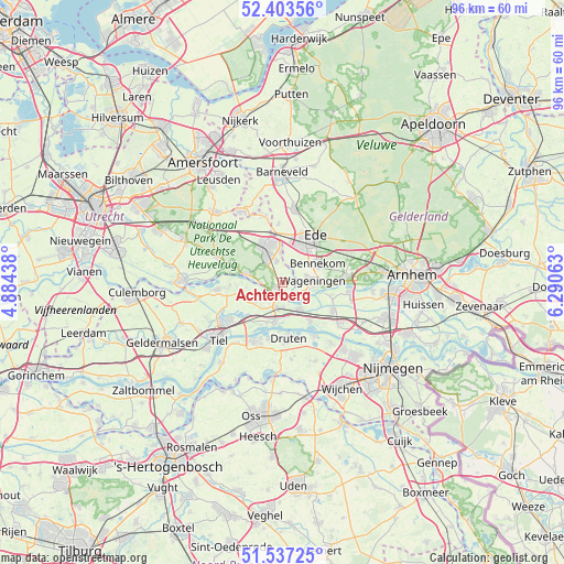
Achterberg GPS coordinates[2]
51° 58' 21" North, 5° 35' 15" East
| Map corner | latitude | longitude |
|---|---|---|
| Upper-left | 52.40356°, | 4.88438° |
| Center: | 51.9725°, | 5.5875° |
| Lower-right: | 51.53725°, | 6.29063° |
| Map W x H: | 96.3×96.3 km | = 59.8×59.8mi |
| max Lat: | 53.48025° ⇑53.1% North |
| Achterberg: | 51.9725° |
| min Lat: | ⇓46.9% South 50.76917° |
| min Long | Achterberg | max Long |
| 3.38611° | 5.5875° | 7.16528° |
| W 47.1%⇐ | ⇒52.9% E |
Elevation
Elevation of Achterberg is 11 m = 36 ft, and this is 4 m = 13 ft below average elevation for this country.
| Max E: |
203 m = 666 ft | 38% |
| Avg. | 15 m = 49 ft | |
| Achterberg | 11 m = 36 ft | |
Min E: |
-6 m = -20 ft | 62% |
See also: Netherlands elevation on elevation.city.
Geographical zone
Achterberg is located in North temperate zone (between Tropic of Cancer and the Arctic Circle). Distance of this North polar circle is 1622.4 km =1008.1 mi to North.| Distance of | km | miles | from Achterberg |
|---|---|---|---|
| North Pole | 4228.3 | 2627.3 | to North |
| Arctic Circle | 1622.4 | 1008.1 | to North |
| Tropic Cancer | 3172.9 | 1971.5 | to South |
| Equator | 5778.8 | 3590.8 | to South |


Nearby cities:
15 places around Achterberg: (largest is in red/bold)
• Bennekom
6.7 km =4.2 mi,  64°
64°
• De Klomp
8.3 km =5.2 mi,  352°
352°
• Druten
9.4 km =5.8 mi,  172°
172°
• Eck en Wiel
9 km =5.6 mi,  267°
267°
• Ede
8.3 km =5.2 mi,  35°
35°
• IJzendoorn
8.3 km =5.2 mi,  206°
206°
• Ingen
7.2 km =4.5 mi,  258°
258°
• Kesteren
4.3 km =2.7 mi,  196°
196°
• Lienden
5.5 km =3.4 mi,  240°
240°
• Ochten
7.1 km =4.4 mi,  190°
190°
• Opheusden
5.5 km =3.4 mi,  146°
146°
• Randwijk
8.5 km =5.3 mi,  104°
104°
• Rhenen
2 km =1.2 mi,  221°
221°
• Veenendaal
6.5 km =4 mi,  342°
342°
• Wageningen
5.4 km =3.4 mi,  92°
92°
Sources, notices
• [Note1] Compared only with cities in Netherlands existing in our database
• [Src1] Map data: © OpenStreetMap contributors (CC-BY-SA)
• [Src2] Other city data from geonames.org with taken over terms of usage.
• [Src3] Geographical zone / Annual Mean Temperature by Robert A. Rohde @ Wikipedia
