Bennekom geodata
Bennekom (Gelderland) is a populated place; located in Netherlands in Europe/Amsterdam (GMT+2) time zone. With population of 14,810 people, there are 225 cities with bigger population in this country. Compared to other cities in Netherlands, 51.1% of cities are located further ↑North; 50.8% of cities are located further ←West and 77.1% of cities have lower elevation than Bennekom. Note1


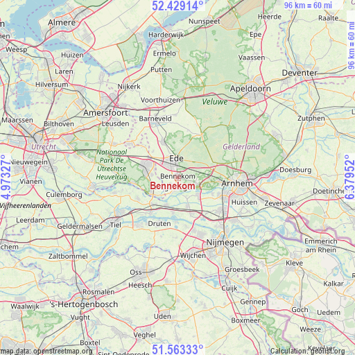
Bennekom GPS coordinates[2]
51° 59' 53.988" North, 5° 40' 35.004" East
| Map corner | latitude | longitude |
|---|---|---|
| Upper-left | 52.42914°, | 4.97327° |
| Center: | 51.99833°, | 5.67639° |
| Lower-right: | 51.56333°, | 6.37952° |
| Map W x H: | 96.3×96.3 km | = 59.8×59.8mi |
| max Lat: | 53.48025° ⇑51.1% North |
| Bennekom: | 51.99833° |
| min Lat: | ⇓48.9% South 50.76917° |
| min Long | Bennekom | max Long |
| 3.38611° | 5.67639° | 7.16528° |
| W 50.8%⇐ | ⇒49.2% E |
Elevation
Elevation of Bennekom is 19 m = 62 ft, and this is 4 m = 13 ft above average elevation for this country.
| Max E: |
203 m = 666 ft | 22.9% |
| Bennekom | 19 m 62 ft | |
| Avg. | 15 m = 49 ft | |
Min E: |
-6 m = -20 ft | 77.1% |
See also: Netherlands elevation on elevation.city.
Geographical zone
Bennekom is located in North temperate zone (between Tropic of Cancer and the Arctic Circle). Distance of this North polar circle is 1619.5 km =1006.3 mi to North.| Distance of | km | miles | from Bennekom |
|---|---|---|---|
| North Pole | 4225.4 | 2625.5 | to North |
| Arctic Circle | 1619.5 | 1006.3 | to North |
| Tropic Cancer | 3175.8 | 1973.4 | to South |
| Equator | 5781.7 | 3592.6 | to South |


Nearby cities:
15 places around Bennekom: (largest is in red/bold)
• Achterberg
6.7 km =4.2 mi,  244°
244°
• De Klomp
8.9 km =5.5 mi,  307°
307°
• Doesburg
8.6 km =5.3 mi,  331°
331°
• Doorwerth
8.5 km =5.3 mi,  104°
104°
• Ede
4.1 km =2.5 mi,  342°
342°
• Heelsum
5.8 km =3.6 mi,  105°
105°
• Heteren
7.1 km =4.4 mi,  130°
130°
• Opheusden
8 km =5 mi,  202°
202°
• Randwijk
5.5 km =3.4 mi,  156°
156°
• Renkum
4.6 km =2.9 mi,  121°
121°
• Rhenen
8.6 km =5.3 mi, 239°
• Veenendaal
8.7 km =5.4 mi,  292°
292°
• Wageningen
3.2 km =2 mi,  191°
191°
• Wolfheze
7.8 km =4.8 mi,  85°
85°
• Zetten
8.2 km =5.1 mi, 161°
Sources, notices
• [Note1] Compared only with cities in Netherlands existing in our database
• [Src1] Map data: © OpenStreetMap contributors (CC-BY-SA)
• [Src2] Other city data from geonames.org with taken over terms of usage.
• [Src3] Geographical zone / Annual Mean Temperature by Robert A. Rohde @ Wikipedia
