Rheden geodata
Rheden (Gelderland) is a populated place; located in Netherlands in Europe/Amsterdam (GMT+2) time zone. With population of 7,400 people, there are 349 cities with bigger population in this country. Compared to other cities in Netherlands, 50.7% of cities are located further ↑North; 74.7% of cities are located further ←West and 73.5% of cities have lower elevation than Rheden. Note1


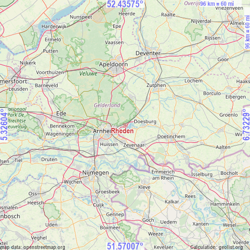
Rheden GPS coordinates[2]
52° 0' 18" North, 6° 1' 45.012" East
| Map corner | latitude | longitude |
|---|---|---|
| Upper-left | 52.43575°, | 5.32604° |
| Center: | 52.005°, | 6.02917° |
| Lower-right: | 51.57007°, | 6.73229° |
| Map W x H: | 96.3×96.3 km | = 59.8×59.8mi |
| max Lat: | 53.48025° ⇑50.7% North |
| Rheden: | 52.005° |
| min Lat: | ⇓49.3% South 50.76917° |
| min Long | Rheden | max Long |
| 3.38611° | 6.02917° | 7.16528° |
| W 74.7%⇐ | ⇒25.3% E |
Elevation
Elevation of Rheden is 17 m = 56 ft, and this is 2 m = 7 ft above average elevation for this country.
| Max E: |
203 m = 666 ft | 26.5% |
| Rheden | 17 m 56 ft | |
| Avg. | 15 m = 49 ft | |
Min E: |
-6 m = -20 ft | 73.5% |
See also: Netherlands elevation on elevation.city.
Geographical zone
Rheden is located in North temperate zone (between Tropic of Cancer and the Arctic Circle). Distance of this North polar circle is 1618.8 km =1005.9 mi to North.| Distance of | km | miles | from Rheden |
|---|---|---|---|
| North Pole | 4224.6 | 2625 | to North |
| Arctic Circle | 1618.8 | 1005.9 | to North |
| Tropic Cancer | 3176.5 | 1973.8 | to South |
| Equator | 5782.4 | 3593 | to South |


Nearby cities:
15 places around Rheden: (largest is in red/bold)
• Angerlo
7.3 km =4.5 mi,  98°
98°
• De Steeg
2.7 km =1.7 mi,  52°
52°
• Dieren
7.2 km =4.5 mi,  42°
42°
• Doesburg
7.6 km =4.7 mi,  83°
83°
• Duiven
6.6 km =4.1 mi,  189°
189°
• Ellecom
5 km =3.1 mi, 52°
• Geitenkamp
6.2 km =3.9 mi,  268°
268°
• Giesbeek
2.9 km =1.8 mi,  116°
116°
• Groessen
8.2 km =5.1 mi,  181°
181°
• Lathum
2.1 km =1.3 mi,  198°
198°
• Rozendaal
4.6 km =2.9 mi, 271°
• Spankeren
8.2 km =5.1 mi, 43°
• Stegeslag
7.4 km =4.6 mi,  162°
162°
• Velp
4 km =2.5 mi,  253°
253°
• Westervoort
6.7 km =4.2 mi,  215°
215°
Sources, notices
• [Note1] Compared only with cities in Netherlands existing in our database
• [Src1] Map data: © OpenStreetMap contributors (CC-BY-SA)
• [Src2] Other city data from geonames.org with taken over terms of usage.
• [Src3] Geographical zone / Annual Mean Temperature by Robert A. Rohde @ Wikipedia
