Doesburg geodata
Doesburg (Gelderland) is a populated place; located in Netherlands in Europe/Amsterdam (GMT+2) time zone. With population of 11,480 people, there are 267 cities with bigger population in this country. Compared to other cities in Netherlands, 50.1% of cities are located further ↑North; 81.1% of cities are located further ←West and 67% of cities have lower elevation than Doesburg. Note1


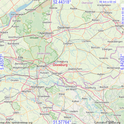
Doesburg GPS coordinates[2]
52° 0' 45" North, 6° 8' 20.004" East
| Map corner | latitude | longitude |
|---|---|---|
| Upper-left | 52.44318°, | 5.43577° |
| Center: | 52.0125°, | 6.13889° |
| Lower-right: | 51.57764°, | 6.84202° |
| Map W x H: | 96.2×96.2 km | = 59.8×59.8mi |
| max Lat: | 53.48025° ⇑50.1% North |
| Doesburg: | 52.0125° |
| min Lat: | ⇓49.9% South 50.76917° |
| min Long | Doesburg | max Long |
| 3.38611° | 6.13889° | 7.16528° |
| W 81.1%⇐ | ⇒18.9% E |
Elevation
Elevation of Doesburg is 13 m = 43 ft, and this is 2 m = 7 ft below average elevation for this country.
| Max E: |
203 m = 666 ft | 33% |
| Avg. | 15 m = 49 ft | |
| Doesburg | 13 m = 43 ft | |
Min E: |
-6 m = -20 ft | 67% |
See also: Netherlands elevation on elevation.city.
Geographical zone
Doesburg is located in North temperate zone (between Tropic of Cancer and the Arctic Circle). Distance of this North polar circle is 1617.9 km =1005.3 mi to North.| Distance of | km | miles | from Doesburg |
|---|---|---|---|
| North Pole | 4223.8 | 2624.5 | to North |
| Arctic Circle | 1617.9 | 1005.3 | to North |
| Tropic Cancer | 3177.3 | 1974.3 | to South |
| Equator | 5783.2 | 3593.5 | to South |


Nearby cities:
15 places around Doesburg: (largest is in red/bold)
• Angerlo
1.9 km =1.2 mi,  188°
188°
• Brummen
8.7 km =5.4 mi,  7°
7°
• De Steeg
5.4 km =3.4 mi,  278°
278°
• Dieren
5.2 km =3.2 mi,  329°
329°
• Drempt
2.5 km =1.6 mi,  102°
102°
• Ellecom
4.2 km =2.6 mi,  302°
302°
• Giesbeek
5.4 km =3.4 mi,  246°
246°
• Hummelo
6.5 km =4 mi, 98°
• Laag-Soeren
9.1 km =5.7 mi, 331°
• Lathum
8.7 km =5.4 mi, 250°
• Loil
6.6 km =4.1 mi,  178°
178°
• Nieuw-Dijk
8.9 km =5.5 mi,  172°
172°
• Rheden
7.6 km =4.7 mi,  263°
263°
• Spankeren
5.4 km =3.4 mi,  340°
340°
• Steenderen
6.6 km =4.1 mi,  30°
30°
Sources, notices
• [Note1] Compared only with cities in Netherlands existing in our database
• [Src1] Map data: © OpenStreetMap contributors (CC-BY-SA)
• [Src2] Other city data from geonames.org with taken over terms of usage.
• [Src3] Geographical zone / Annual Mean Temperature by Robert A. Rohde @ Wikipedia
