Puth geodata
Puth (Limburg) is a populated place; located in Netherlands in Europe/Amsterdam (GMT+2) time zone. With population of 1,990 people, there are 963 cities with bigger population in this country. Compared to other cities in Netherlands, 94.4% of cities are located further ↑North; 62.2% of cities are located further ←West and 97.1% of cities have lower elevation than Puth. Note1


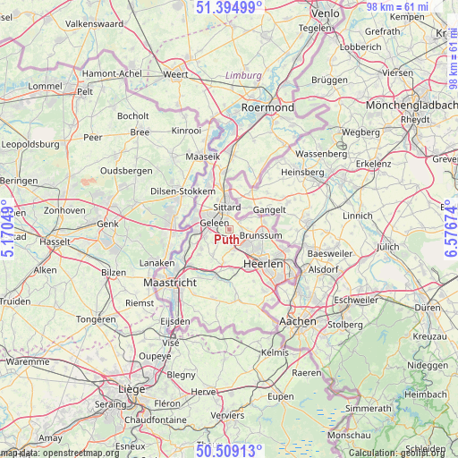
Puth GPS coordinates[2]
50° 57' 15.012" North, 5° 52' 24.996" East
| Map corner | latitude | longitude |
|---|---|---|
| Upper-left | 51.39499°, | 5.17049° |
| Center: | 50.95417°, | 5.87361° |
| Lower-right: | 50.50913°, | 6.57674° |
| Map W x H: | 98.5×98.5 km | = 61.2×61.2mi |
| max Lat: | 53.48025° ⇑94.4% North |
| Puth: | 50.95417° |
| min Lat: | ⇓5.6% South 50.76917° |
| min Long | Puth | max Long |
| 3.38611° | 5.87361° | 7.16528° |
| W 62.2%⇐ | ⇒37.8% E |
Elevation
Elevation of Puth is 101 m = 331 ft, and this is 86 m = 282 ft above average elevation for this country.
| Max E: |
203 m = 666 ft | 2.9% |
| Puth | 101 m 331 ft | |
| Avg. | 15 m = 49 ft | |
Min E: |
-6 m = -20 ft | 97.1% |
See also: Netherlands elevation on elevation.city.
Geographical zone
Puth is located in North temperate zone (between Tropic of Cancer and the Arctic Circle). Distance of this North polar circle is 1735.6 km =1078.5 mi to North.| Distance of | km | miles | from Puth |
|---|---|---|---|
| North Pole | 4341.5 | 2697.7 | to North |
| Arctic Circle | 1735.6 | 1078.5 | to North |
| Tropic Cancer | 3059.7 | 1901.2 | to South |
| Equator | 5665.6 | 3520.4 | to South |


Nearby cities:
15 places around Puth: (largest is in red/bold)
• Amstenrade
3.9 km =2.4 mi,  115°
115°
• Bingelrade
4.5 km =2.8 mi,  56°
56°
• Doenrade
2.8 km =1.7 mi, 57°
• Geleen
3.8 km =2.4 mi,  305°
305°
• Hommert
3.6 km =2.2 mi, 124°
• Merkelbeek
4.7 km =2.9 mi,  90°
90°
• Munstergeleen
2.4 km =1.5 mi,  343°
343°
• Neerbeek
4.1 km =2.5 mi,  263°
263°
• Nuth
4.2 km =2.6 mi,  167°
167°
• Oirsbeek
2.5 km =1.6 mi,  98°
98°
• Ophoven
4.2 km =2.6 mi,  345°
345°
• Schinnen
1.6 km =1 mi,  138°
138°
• Spaubeek
2.7 km =1.7 mi,  233°
233°
• Sweikhuizen
1.8 km =1.1 mi,  270°
270°
• Vaesrade
3.6 km =2.2 mi, 139°
Sources, notices
• [Note1] Compared only with cities in Netherlands existing in our database
• [Src1] Map data: © OpenStreetMap contributors (CC-BY-SA)
• [Src2] Other city data from geonames.org with taken over terms of usage.
• [Src3] Geographical zone / Annual Mean Temperature by Robert A. Rohde @ Wikipedia
