Geleen geodata
Geleen (Limburg) is a populated place; located in Netherlands in Europe/Amsterdam (GMT+2) time zone. With population of 32,790 people, there are 97 cities with bigger population in this country. Compared to other cities in Netherlands, 94% of cities are located further ↑North; 59.9% of cities are located further ←West and 95.3% of cities have lower elevation than Geleen. Note1


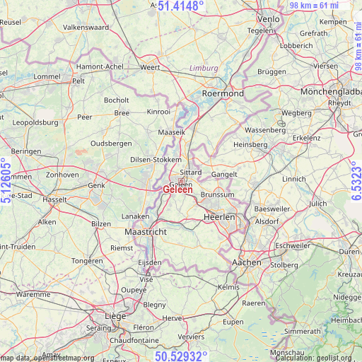
Geleen GPS coordinates[2]
50° 58' 27.012" North, 5° 49' 45.012" East
| Map corner | latitude | longitude |
|---|---|---|
| Upper-left | 51.4148°, | 5.12605° |
| Center: | 50.97417°, | 5.82917° |
| Lower-right: | 50.52932°, | 6.5323° |
| Map W x H: | 98.5×98.5 km | = 61.2×61.2mi |
| max Lat: | 53.48025° ⇑94% North |
| Geleen: | 50.97417° |
| min Lat: | ⇓6% South 50.76917° |
| min Long | Geleen | max Long |
| 3.38611° | 5.82917° | 7.16528° |
| W 59.9%⇐ | ⇒40.1% E |
Elevation
Elevation of Geleen is 66 m = 217 ft, and this is 51 m = 167 ft above average elevation for this country.
| Max E: |
203 m = 666 ft | 4.7% |
| Geleen | 66 m 217 ft | |
| Avg. | 15 m = 49 ft | |
Min E: |
-6 m = -20 ft | 95.3% |
See also: Netherlands elevation on elevation.city.
Geographical zone
Geleen is located in North temperate zone (between Tropic of Cancer and the Arctic Circle). Distance of this North polar circle is 1733.4 km =1077.1 mi to North.| Distance of | km | miles | from Geleen |
|---|---|---|---|
| North Pole | 4339.3 | 2696.3 | to North |
| Arctic Circle | 1733.4 | 1077.1 | to North |
| Tropic Cancer | 3061.9 | 1902.6 | to South |
| Equator | 5667.8 | 3521.8 | to South |


Nearby cities:
15 places around Geleen: (largest is in red/bold)
• Beek
4.3 km =2.7 mi,  211°
211°
• Einighausen
3.1 km =1.9 mi,  358°
358°
• Kerensheide
3.7 km =2.3 mi,  266°
266°
• Limbricht
4.2 km =2.6 mi,  7°
7°
• Lindenheuvel
1.5 km =0.9 mi,  324°
324°
• Munstergeleen
2.4 km =1.5 mi,  87°
87°
• Neerbeek
2.9 km =1.8 mi,  199°
199°
• Nieuwdorp
4.2 km =2.6 mi,  251°
251°
• Ophoven
2.7 km =1.7 mi,  48°
48°
• Puth
3.8 km =2.4 mi,  125°
125°
• Sittard
3.9 km =2.4 mi, 46°
• Spaubeek
3.9 km =2.4 mi,  165°
165°
• Stein
4.4 km =2.7 mi,  262°
262°
• Sweikhuizen
2.6 km =1.6 mi,  150°
150°
• Urmond
4.4 km =2.7 mi,  294°
294°
Sources, notices
• [Note1] Compared only with cities in Netherlands existing in our database
• [Src1] Map data: © OpenStreetMap contributors (CC-BY-SA)
• [Src2] Other city data from geonames.org with taken over terms of usage.
• [Src3] Geographical zone / Annual Mean Temperature by Robert A. Rohde @ Wikipedia
