Posterholt geodata
Posterholt (Limburg) is a populated place; located in Netherlands in Europe/Amsterdam (GMT+2) time zone. With population of 3,540 people, there are 666 cities with bigger population in this country. Compared to other cities in Netherlands, 92.4% of cities are located further ↑North; 74.9% of cities are located further ←West and 89.8% of cities have lower elevation than Posterholt. Note1


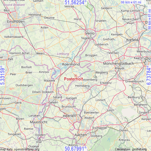
Posterholt GPS coordinates[2]
51° 7' 23.988" North, 6° 2' 4.992" East
| Map corner | latitude | longitude |
|---|---|---|
| Upper-left | 51.56254°, | 5.33159° |
| Center: | 51.12333°, | 6.03472° |
| Lower-right: | 50.67991°, | 6.73784° |
| Map W x H: | 98.1×98.1 km | = 61×61mi |
| max Lat: | 53.48025° ⇑92.4% North |
| Posterholt: | 51.12333° |
| min Lat: | ⇓7.6% South 50.76917° |
| min Long | Posterholt | max Long |
| 3.38611° | 6.03472° | 7.16528° |
| W 74.9%⇐ | ⇒25.1% E |
Elevation
Elevation of Posterholt is 33 m = 108 ft, and this is 18 m = 59 ft above average elevation for this country.
| Max E: |
203 m = 666 ft | 10.2% |
| Posterholt | 33 m 108 ft | |
| Avg. | 15 m = 49 ft | |
Min E: |
-6 m = -20 ft | 89.8% |
See also: Netherlands elevation on elevation.city.
Geographical zone
Posterholt is located in North temperate zone (between Tropic of Cancer and the Arctic Circle). Distance of this North polar circle is 1716.8 km =1066.8 mi to North.| Distance of | km | miles | from Posterholt |
|---|---|---|---|
| North Pole | 4322.7 | 2686 | to North |
| Arctic Circle | 1716.8 | 1066.8 | to North |
| Tropic Cancer | 3078.5 | 1912.9 | to South |
| Equator | 5684.4 | 3532.1 | to South |


Nearby cities:
15 places around Posterholt: (largest is in red/bold)
• Asenray
7.8 km =4.8 mi,  7°
7°
• Brachterbeek
9.5 km =5.9 mi,  286°
286°
• Herkenbosch
3.9 km =2.4 mi,  31°
31°
• Herten
8.1 km =5 mi,  321°
321°
• Hingen
9.7 km =6 mi,  257°
257°
• Kitskensberg
5.8 km =3.6 mi,  338°
338°
• Koningsbosch
9.6 km =6 mi,  213°
213°
• Linne
7.6 km =4.7 mi,  297°
297°
• Melick
4.2 km =2.6 mi, 342°
• Merum
7.6 km =4.7 mi, 316°
• Montfort
6 km =3.7 mi,  272°
272°
• Roermond
8.5 km =5.3 mi, 337°
• Sint Joost
9.5 km =5.9 mi, 266°
• Sint Odiliënberg
3.3 km =2.1 mi,  312°
312°
• Vlodrop
3.1 km =1.9 mi,  69°
69°
Sources, notices
• [Note1] Compared only with cities in Netherlands existing in our database
• [Src1] Map data: © OpenStreetMap contributors (CC-BY-SA)
• [Src2] Other city data from geonames.org with taken over terms of usage.
• [Src3] Geographical zone / Annual Mean Temperature by Robert A. Rohde @ Wikipedia
