Koningsbosch geodata
Koningsbosch (Limburg) is a populated place; located in Netherlands in Europe/Amsterdam (GMT+2) time zone. With population of 1,540 people, there are 1111 cities with bigger population in this country. Compared to other cities in Netherlands, 92.9% of cities are located further ↑North; 68.7% of cities are located further ←West and 95% of cities have lower elevation than Koningsbosch. Note1


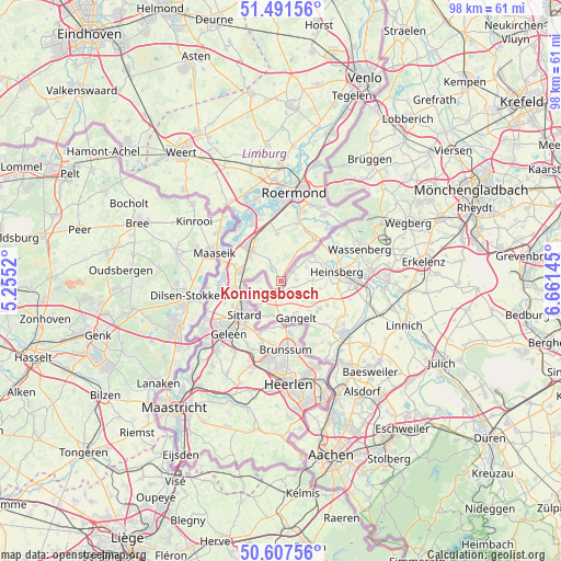
Koningsbosch GPS coordinates[2]
51° 3' 6.012" North, 5° 57' 29.988" East
| Map corner | latitude | longitude |
|---|---|---|
| Upper-left | 51.49156°, | 5.2552° |
| Center: | 51.05167°, | 5.95833° |
| Lower-right: | 50.60756°, | 6.66145° |
| Map W x H: | 98.3×98.3 km | = 61.1×61.1mi |
| max Lat: | 53.48025° ⇑92.9% North |
| Koningsbosch: | 51.05167° |
| min Lat: | ⇓7.1% South 50.76917° |
| min Long | Koningsbosch | max Long |
| 3.38611° | 5.95833° | 7.16528° |
| W 68.7%⇐ | ⇒31.3% E |
Elevation
Elevation of Koningsbosch is 63 m = 207 ft, and this is 48 m = 157 ft above average elevation for this country.
| Max E: |
203 m = 666 ft | 5% |
| Koningsbosch | 63 m 207 ft | |
| Avg. | 15 m = 49 ft | |
Min E: |
-6 m = -20 ft | 95% |
See also: Netherlands elevation on elevation.city.
Geographical zone
Koningsbosch is located in North temperate zone (between Tropic of Cancer and the Arctic Circle). Distance of this North polar circle is 1724.8 km =1071.7 mi to North.| Distance of | km | miles | from Koningsbosch |
|---|---|---|---|
| North Pole | 4330.6 | 2690.9 | to North |
| Arctic Circle | 1724.8 | 1071.7 | to North |
| Tropic Cancer | 3070.5 | 1907.9 | to South |
| Equator | 5676.4 | 3527.2 | to South |


Nearby cities:
15 places around Koningsbosch: (largest is in red/bold)
• Bingelrade
8.7 km =5.4 mi,  194°
194°
• Broeksittard
7 km =4.3 mi,  219°
219°
• Dieteren
8.3 km =5.2 mi,  289°
289°
• Heide
6.3 km =3.9 mi, 287°
• Hingen
7.3 km =4.5 mi,  324°
324°
• Jabeek
8 km =5 mi, 188°
• Montfort
8.3 km =5.2 mi,  355°
355°
• Overhoven
8 km =5 mi,  233°
233°
• Peij
6.4 km =4 mi, 317°
• Schilberg
7.3 km =4.5 mi, 316°
• Schinveld
9.3 km =5.8 mi,  170°
170°
• Sint Joost
8.4 km =5.2 mi,  330°
330°
• Sittard
8.6 km =5.3 mi, 226°
• Slek
6.6 km =4.1 mi,  305°
305°
• Stadbroek
8 km =5 mi, 225°
Sources, notices
• [Note1] Compared only with cities in Netherlands existing in our database
• [Src1] Map data: © OpenStreetMap contributors (CC-BY-SA)
• [Src2] Other city data from geonames.org with taken over terms of usage.
• [Src3] Geographical zone / Annual Mean Temperature by Robert A. Rohde @ Wikipedia
