Herkenbosch geodata
Herkenbosch (Limburg) is a populated place; located in Netherlands in Europe/Amsterdam (GMT+2) time zone. With population of 3,935 people, there are 596 cities with bigger population in this country. Compared to other cities in Netherlands, 92.1% of cities are located further ↑North; 77.1% of cities are located further ←West and 89.2% of cities have lower elevation than Herkenbosch. Note1


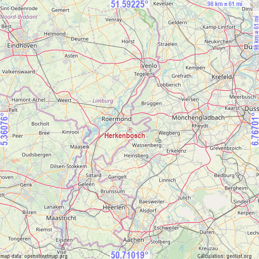
Herkenbosch GPS coordinates[2]
51° 9' 11.988" North, 6° 3' 50.004" East
| Map corner | latitude | longitude |
|---|---|---|
| Upper-left | 51.59225°, | 5.36076° |
| Center: | 51.15333°, | 6.06389° |
| Lower-right: | 50.71019°, | 6.76701° |
| Map W x H: | 98.1×98.1 km | = 61×61mi |
| max Lat: | 53.48025° ⇑92.1% North |
| Herkenbosch: | 51.15333° |
| min Lat: | ⇓7.9% South 50.76917° |
| min Long | Herkenbosch | max Long |
| 3.38611° | 6.06389° | 7.16528° |
| W 77.1%⇐ | ⇒22.9% E |
Elevation
Elevation of Herkenbosch is 32 m = 105 ft, and this is 17 m = 56 ft above average elevation for this country.
| Max E: |
203 m = 666 ft | 10.8% |
| Herkenbosch | 32 m 105 ft | |
| Avg. | 15 m = 49 ft | |
Min E: |
-6 m = -20 ft | 89.2% |
See also: Netherlands elevation on elevation.city.
Geographical zone
Herkenbosch is located in North temperate zone (between Tropic of Cancer and the Arctic Circle). Distance of this North polar circle is 1713.5 km =1064.7 mi to North.| Distance of | km | miles | from Herkenbosch |
|---|---|---|---|
| North Pole | 4319.3 | 2683.9 | to North |
| Arctic Circle | 1713.5 | 1064.7 | to North |
| Tropic Cancer | 3081.8 | 1914.9 | to South |
| Equator | 5687.7 | 3534.2 | to South |


Nearby cities:
15 places around Herkenbosch: (largest is in red/bold)
• Asenray
4.6 km =2.9 mi,  346°
346°
• Beegden
10.8 km =6.7 mi,  291°
291°
• Boukoul
7 km =4.3 mi, 350°
• Heide
9.8 km =6.1 mi, 351°
• Herten
7.7 km =4.8 mi, 293°
• Kitskensberg
4.6 km =2.9 mi,  296°
296°
• Leeuwen
7.8 km =4.8 mi,  324°
324°
• Linne
8.7 km =5.4 mi,  271°
271°
• Melick
3.4 km =2.1 mi,  281°
281°
• Merum
7.6 km =4.7 mi, 287°
• Montfort
8.6 km =5.3 mi,  249°
249°
• Posterholt
3.9 km =2.4 mi,  211°
211°
• Roermond
7 km =4.3 mi,  310°
310°
• Sint Odiliënberg
4.6 km =2.9 mi,  255°
255°
• Vlodrop
2.4 km =1.5 mi,  158°
158°
Sources, notices
• [Note1] Compared only with cities in Netherlands existing in our database
• [Src1] Map data: © OpenStreetMap contributors (CC-BY-SA)
• [Src2] Other city data from geonames.org with taken over terms of usage.
• [Src3] Geographical zone / Annual Mean Temperature by Robert A. Rohde @ Wikipedia
