Oosterhoogebrug geodata
Oosterhoogebrug (Groningen) is a section of populated place; located in Netherlands in Europe/Amsterdam (GMT+2) time zone. With population of 2,210 people, there are 907 cities with bigger population in this country. Compared to other cities in Netherlands, 94.7% of cities are located further ↓South; 91.3% of cities are located further ←West and 91.3% of cities have higher elevation than Oosterhoogebrug. Note1


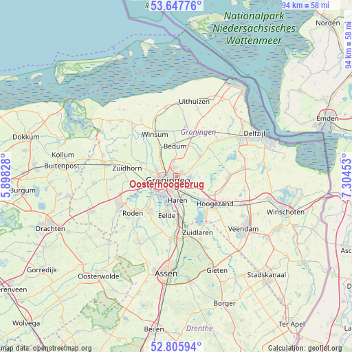
Oosterhoogebrug GPS coordinates[2]
53° 13' 44.112" North, 6° 36' 5.076" East
| Map corner | latitude | longitude |
|---|---|---|
| Upper-left | 53.64776°, | 5.89828° |
| Center: | 53.22892°, | 6.60141° |
| Lower-right: | 52.80594°, | 7.30453° |
| Map W x H: | 93.6×93.6 km | = 58.2×58.2mi |
| max Lat: | 53.48025° ⇑5.3% North |
| Oosterhoogebrug: | 53.22892° |
| min Lat: | ⇓94.7% South 50.76917° |
| min Long | Oosterhoogebrug | max Long |
| 3.38611° | 6.60141° | 7.16528° |
| W 91.3%⇐ | ⇒8.7% E |
Elevation
Elevation of Oosterhoogebrug is 0 m = 0 ft, and this is 15 m = 49 ft below average elevation for this country.
| Max E: |
203 m = 666 ft | 91.3% |
| Avg. | 15 m = 49 ft | |
| Oosterhoogebrug | 0 m = 0 ft | |
Min E: |
-6 m = -20 ft | 8.7% |
See also: Netherlands elevation on elevation.city.
Geographical zone
Oosterhoogebrug is located in North temperate zone (between Tropic of Cancer and the Arctic Circle). Distance of this North polar circle is 1482.7 km =921.3 mi to North.| Distance of | km | miles | from Oosterhoogebrug |
|---|---|---|---|
| North Pole | 4088.6 | 2540.5 | to North |
| Arctic Circle | 1482.7 | 921.3 | to North |
| Tropic Cancer | 3312.6 | 2058.4 | to South |
| Equator | 5918.5 | 3677.6 | to South |


Nearby cities:
15 places around Oosterhoogebrug: (largest is in red/bold)
• Adorp
6.8 km =4.2 mi,  318°
318°
• Coendersborg
4 km =2.5 mi,  191°
191°
• De Wijert
4.3 km =2.7 mi,  207°
207°
• Engelbert
3.8 km =2.4 mi,  126°
126°
• Groningen
2.6 km =1.6 mi,  244°
244°
• Haren
6.3 km =3.9 mi,  175°
175°
• Harkstede
6.7 km =4.2 mi,  104°
104°
• Helpman
3.7 km =2.3 mi,  202°
202°
• Korrewegwijk
2.3 km =1.4 mi,  279°
279°
• Oosterpark
1.2 km =0.7 mi, 241°
• Reitdiep
5.7 km =3.5 mi,  285°
285°
• Scharmer
7.4 km =4.6 mi,  110°
110°
• Selwerd
3.2 km =2 mi, 282°
• Van Starkenborgh
2.1 km =1.3 mi,  303°
303°
• Zuidwolde
3.8 km =2.4 mi,  350°
350°
Sources, notices
• [Note1] Compared only with cities in Netherlands existing in our database
• [Src1] Map data: © OpenStreetMap contributors (CC-BY-SA)
• [Src2] Other city data from geonames.org with taken over terms of usage.
• [Src3] Geographical zone / Annual Mean Temperature by Robert A. Rohde @ Wikipedia
