Helpman geodata
Helpman (Groningen) is a section of populated place; located in Netherlands in Europe/Amsterdam (GMT+2) time zone. With population of 6,050 people, there are 407 cities with bigger population in this country. Compared to other cities in Netherlands, 93% of cities are located further ↓South; 90.7% of cities are located further ←West and 52.4% of cities have lower elevation than Helpman. Note1


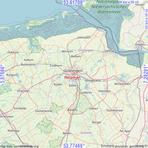
Helpman GPS coordinates[2]
53° 11' 52.584" North, 6° 34' 47.208" East
| Map corner | latitude | longitude |
|---|---|---|
| Upper-left | 53.61708°, | 5.87666° |
| Center: | 53.19794°, | 6.57978° |
| Lower-right: | 52.77466°, | 7.28291° |
| Map W x H: | 93.7×93.7 km | = 58.2×58.2mi |
| max Lat: | 53.48025° ⇑7% North |
| Helpman: | 53.19794° |
| min Lat: | ⇓93% South 50.76917° |
| min Long | Helpman | max Long |
| 3.38611° | 6.57978° | 7.16528° |
| W 90.7%⇐ | ⇒9.3% E |
Elevation
Elevation of Helpman is 7 m = 23 ft, and this is 8 m = 26 ft below average elevation for this country.
| Max E: |
203 m = 666 ft | 47.6% |
| Avg. | 15 m = 49 ft | |
| Helpman | 7 m = 23 ft | |
Min E: |
-6 m = -20 ft | 52.4% |
See also: Netherlands elevation on elevation.city.
Geographical zone
Helpman is located in North temperate zone (between Tropic of Cancer and the Arctic Circle). Distance of this North polar circle is 1486.1 km =923.4 mi to North.| Distance of | km | miles | from Helpman |
|---|---|---|---|
| North Pole | 4092 | 2542.7 | to North |
| Arctic Circle | 1486.1 | 923.4 | to North |
| Tropic Cancer | 3309.1 | 2056.2 | to South |
| Equator | 5915.1 | 3675.5 | to South |


Nearby cities:
15 places around Helpman: (largest is in red/bold)
• Coendersborg
0.8 km =0.5 mi,  123°
123°
• De Wijert
0.7 km =0.4 mi,  236°
236°
• Eelde
7 km =4.3 mi,  189°
189°
• Engelbert
4.6 km =2.9 mi,  75°
75°
• Glimmen
7.3 km =4.5 mi,  153°
153°
• Groningen
2.5 km =1.6 mi,  339°
339°
• Haren
3.5 km =2.2 mi, 145°
• Korrewegwijk
3.9 km =2.4 mi,  348°
348°
• Oosterhoogebrug
3.7 km =2.3 mi,  22°
22°
• Oosterpark
2.9 km =1.8 mi,  7°
7°
• Paterswolde
6 km =3.7 mi, 189°
• Reitdiep
6.4 km =4 mi,  321°
321°
• Selwerd
4.5 km =2.8 mi, 337°
• Van Starkenborgh
4.6 km =2.9 mi,  355°
355°
• Zuidwolde
7.2 km =4.5 mi, 6°
Sources, notices
• [Note1] Compared only with cities in Netherlands existing in our database
• [Src1] Map data: © OpenStreetMap contributors (CC-BY-SA)
• [Src2] Other city data from geonames.org with taken over terms of usage.
• [Src3] Geographical zone / Annual Mean Temperature by Robert A. Rohde @ Wikipedia
