Groningen geodata
Groningen is a seat of a first-order administrative division; located in Netherlands in Europe/Amsterdam (GMT+2) time zone. With population of 181,194 people, there are 6 cities with bigger population in this country. Compared to other cities in Netherlands, 94.3% of cities are located further ↓South; 90.4% of cities are located further ←West and 72.5% of cities have lower elevation than Groningen. Note1


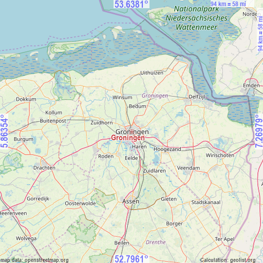
Groningen GPS coordinates[2]
53° 13' 9.012" North, 6° 34' 0.012" East
| Map corner | latitude | longitude |
|---|---|---|
| Upper-left | 53.6381°, | 5.86354° |
| Center: | 53.21917°, | 6.56667° |
| Lower-right: | 52.7961°, | 7.26979° |
| Map W x H: | 93.6×93.6 km | = 58.2×58.2mi |
| max Lat: | 53.48025° ⇑5.7% North |
| Groningen: | 53.21917° |
| min Lat: | ⇓94.3% South 50.76917° |
| min Long | Groningen | max Long |
| 3.38611° | 6.56667° | 7.16528° |
| W 90.4%⇐ | ⇒9.6% E |
Elevation
Elevation of Groningen is 16 m = 52 ft, and this is 1 m = 3 ft above average elevation for this country.
| Max E: |
203 m = 666 ft | 27.5% |
| Groningen | 16 m 52 ft | |
| Avg. | 15 m = 49 ft | |
Min E: |
-6 m = -20 ft | 72.5% |
See also: Groningen elevation on elevation.city.
Geographical zone
Groningen is located in North temperate zone (between Tropic of Cancer and the Arctic Circle). Distance of this North polar circle is 1483.8 km =922 mi to North.| Distance of | km | miles | from Groningen |
|---|---|---|---|
| North Pole | 4089.6 | 2541.2 | to North |
| Arctic Circle | 1483.8 | 922 | to North |
| Tropic Cancer | 3311.5 | 2057.7 | to South |
| Equator | 5917.4 | 3676.9 | to South |


Nearby cities:
15 places around Groningen: (largest is in red/bold)
• Adorp
6.6 km =4.1 mi,  340°
340°
• Aduard
8.2 km =5.1 mi,  300°
300°
• Coendersborg
3.2 km =2 mi,  151°
151°
• De Wijert
2.8 km =1.7 mi,  173°
173°
• Engelbert
5.5 km =3.4 mi,  102°
102°
• Haren
6 km =3.7 mi, 151°
• Helpman
2.5 km =1.6 mi,  159°
159°
• Korrewegwijk
1.5 km =0.9 mi,  3°
3°
• Oosterhoogebrug
2.6 km =1.6 mi,  64°
64°
• Oosterpark
1.3 km =0.8 mi,  67°
67°
• Paterswolde
8.2 km =5.1 mi,  180°
180°
• Reitdiep
4.1 km =2.5 mi,  309°
309°
• Selwerd
2 km =1.2 mi, 335°
• Van Starkenborgh
2.3 km =1.4 mi,  13°
13°
• Zuidwolde
5.1 km =3.2 mi,  19°
19°
In other languages:
- In Spanish: Groninga
- In France: Groningue
- In Italian: Groninga
- In Russian: Гронинген
- In Chinese: 格罗宁根
Sources, notices
• [Note1] Compared only with cities in Netherlands existing in our database
• [Src1] Map data: © OpenStreetMap contributors (CC-BY-SA)
• [Src2] Other city data from geonames.org with taken over terms of usage.
• [Src3] Geographical zone / Annual Mean Temperature by Robert A. Rohde @ Wikipedia
