Oosterholt geodata
Oosterholt (Overijssel) is a populated place; located in Netherlands in Europe/Amsterdam (GMT+2) time zone. With population of 1,175 people, there are 1294 cities with bigger population in this country. Compared to other cities in Netherlands, 72.9% of cities are located further ↓South; 68.3% of cities are located further ←West and 83.9% of cities have higher elevation than Oosterholt. Note1


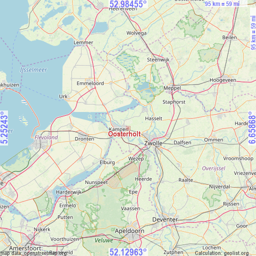
Oosterholt GPS coordinates[2]
52° 33' 33.012" North, 5° 57' 20.016" East
| Map corner | latitude | longitude |
|---|---|---|
| Upper-left | 52.98455°, | 5.25243° |
| Center: | 52.55917°, | 5.95556° |
| Lower-right: | 52.12963°, | 6.65868° |
| Map W x H: | 95.1×95.1 km | = 59.1×59.1mi |
| max Lat: | 53.48025° ⇑27.1% North |
| Oosterholt: | 52.55917° |
| min Lat: | ⇓72.9% South 50.76917° |
| min Long | Oosterholt | max Long |
| 3.38611° | 5.95556° | 7.16528° |
| W 68.3%⇐ | ⇒31.7% E |
Elevation
Elevation of Oosterholt is 1 m = 3 ft, and this is 14 m = 46 ft below average elevation for this country.
| Max E: |
203 m = 666 ft | 83.9% |
| Avg. | 15 m = 49 ft | |
| Oosterholt | 1 m = 3 ft | |
Min E: |
-6 m = -20 ft | 16.1% |
See also: Netherlands elevation on elevation.city.
Geographical zone
Oosterholt is located in North temperate zone (between Tropic of Cancer and the Arctic Circle). Distance of this North polar circle is 1557.1 km =967.5 mi to North.| Distance of | km | miles | from Oosterholt |
|---|---|---|---|
| North Pole | 4163 | 2586.8 | to North |
| Arctic Circle | 1557.1 | 967.5 | to North |
| Tropic Cancer | 3238.1 | 2012.1 | to South |
| Equator | 5844 | 3631.3 | to South |


Nearby cities:
15 places around Oosterholt: (largest is in red/bold)
• Brinkhoek
11.6 km =7.2 mi,  102°
102°
• Broekdijk
12.2 km =7.6 mi,  187°
187°
• Brunnepe
3.5 km =2.2 mi,  274°
274°
• Ens
12.2 km =7.6 mi,  314°
314°
• Flevowijk
3.2 km =2 mi,  242°
242°
• Frankhuis
8.5 km =5.3 mi,  116°
116°
• Grafhorst
3 km =1.9 mi,  329°
329°
• Hasselt
10.1 km =6.3 mi,  68°
68°
• Hattem
11.9 km =7.4 mi,  141°
141°
• Hattemerbroek
10.5 km =6.5 mi,  154°
154°
• Kampen
3 km =1.9 mi,  261°
261°
• Kamperveen
5.9 km =3.7 mi,  196°
196°
• Oosterwolde
11.2 km =7 mi, 202°
• Wilsum
3.5 km =2.2 mi,  167°
167°
• Zwolle
10.7 km =6.6 mi, 118°
Sources, notices
• [Note1] Compared only with cities in Netherlands existing in our database
• [Src1] Map data: © OpenStreetMap contributors (CC-BY-SA)
• [Src2] Other city data from geonames.org with taken over terms of usage.
• [Src3] Geographical zone / Annual Mean Temperature by Robert A. Rohde @ Wikipedia
