Kampen geodata
Kampen (Overijssel) is a populated place; located in Netherlands in Europe/Amsterdam (GMT+2) time zone. With population of 48,980 people, there are 60 cities with bigger population in this country. Compared to other cities in Netherlands, 72.8% of cities are located further ↓South; 65.2% of cities are located further ←West and 74.9% of cities have higher elevation than Kampen. Note1


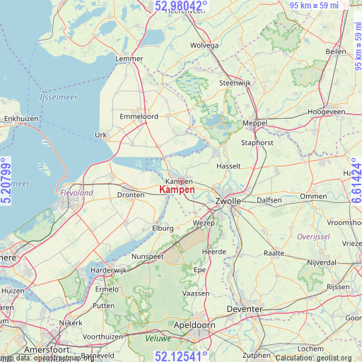
Kampen GPS coordinates[2]
52° 33' 18" North, 5° 54' 39.996" East
| Map corner | latitude | longitude |
|---|---|---|
| Upper-left | 52.98042°, | 5.20799° |
| Center: | 52.555°, | 5.91111° |
| Lower-right: | 52.12541°, | 6.61424° |
| Map W x H: | 95.1×95.1 km | = 59.1×59.1mi |
| max Lat: | 53.48025° ⇑27.2% North |
| Kampen: | 52.555° |
| min Lat: | ⇓72.8% South 50.76917° |
| min Long | Kampen | max Long |
| 3.38611° | 5.91111° | 7.16528° |
| W 65.2%⇐ | ⇒34.8% E |
Elevation
Elevation of Kampen is 2 m = 7 ft, and this is 13 m = 43 ft below average elevation for this country.
| Max E: |
203 m = 666 ft | 74.9% |
| Avg. | 15 m = 49 ft | |
| Kampen | 2 m = 7 ft | |
Min E: |
-6 m = -20 ft | 25.1% |
See also: Kampen elevation on elevation.city.
Geographical zone
Kampen is located in North temperate zone (between Tropic of Cancer and the Arctic Circle). Distance of this North polar circle is 1557.6 km =967.8 mi to North.| Distance of | km | miles | from Kampen |
|---|---|---|---|
| North Pole | 4163.5 | 2587.1 | to North |
| Arctic Circle | 1557.6 | 967.8 | to North |
| Tropic Cancer | 3237.6 | 2011.8 | to South |
| Equator | 5843.6 | 3631 | to South |


Nearby cities:
15 places around Kampen: (largest is in red/bold)
• Broekdijk
11.8 km =7.3 mi,  172°
172°
• Brunnepe
0.9 km =0.6 mi,  325°
325°
• Elburg
12.8 km =8 mi,  201°
201°
• Ens
10.7 km =6.6 mi, 328°
• Flevowijk
1 km =0.6 mi, 171°
• Frankhuis
11.1 km =6.9 mi,  107°
107°
• Grafhorst
3.4 km =2.1 mi,  26°
26°
• Hattemerbroek
11.7 km =7.3 mi,  140°
140°
• Kamperveen
5.4 km =3.4 mi, 165°
• Ketelhaven
10.3 km =6.4 mi,  283°
283°
• Oldebroek
12.2 km =7.6 mi,  183°
183°
• Oostendorp
12.6 km =7.8 mi, 197°
• Oosterholt
3 km =1.9 mi,  81°
81°
• Oosterwolde
10 km =6.2 mi,  187°
187°
• Wilsum
4.8 km =3 mi,  128°
128°
Sources, notices
• [Note1] Compared only with cities in Netherlands existing in our database
• [Src1] Map data: © OpenStreetMap contributors (CC-BY-SA)
• [Src2] Other city data from geonames.org with taken over terms of usage.
• [Src3] Geographical zone / Annual Mean Temperature by Robert A. Rohde @ Wikipedia
