Wilsum geodata
Wilsum (Overijssel) is a populated place; located in Netherlands in Europe/Amsterdam (GMT+2) time zone. With population of 815 people, there are 1518 cities with bigger population in this country. Compared to other cities in Netherlands, 72.3% of cities are located further ↓South; 69.5% of cities are located further ←West and 65.8% of cities have higher elevation than Wilsum. Note1


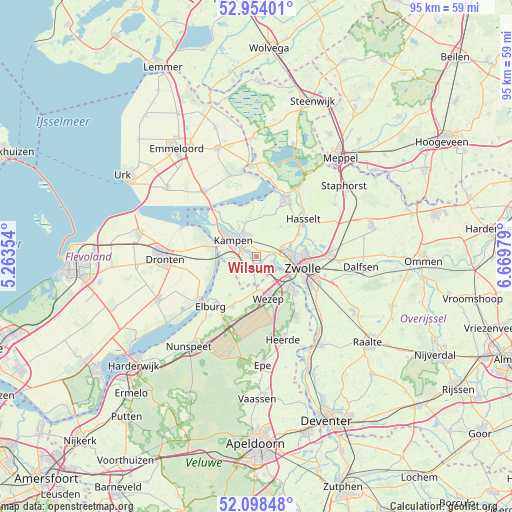
Wilsum GPS coordinates[2]
52° 31' 41.988" North, 5° 58' 0.012" East
| Map corner | latitude | longitude |
|---|---|---|
| Upper-left | 52.95401°, | 5.26354° |
| Center: | 52.52833°, | 5.96667° |
| Lower-right: | 52.09848°, | 6.66979° |
| Map W x H: | 95.1×95.1 km | = 59.1×59.1mi |
| max Lat: | 53.48025° ⇑27.7% North |
| Wilsum: | 52.52833° |
| min Lat: | ⇓72.3% South 50.76917° |
| min Long | Wilsum | max Long |
| 3.38611° | 5.96667° | 7.16528° |
| W 69.5%⇐ | ⇒30.5% E |
Elevation
Elevation of Wilsum is 3 m = 10 ft, and this is 12 m = 39 ft below average elevation for this country.
| Max E: |
203 m = 666 ft | 65.8% |
| Avg. | 15 m = 49 ft | |
| Wilsum | 3 m = 10 ft | |
Min E: |
-6 m = -20 ft | 34.2% |
See also: Netherlands elevation on elevation.city.
Geographical zone
Wilsum is located in North temperate zone (between Tropic of Cancer and the Arctic Circle). Distance of this North polar circle is 1560.6 km =969.7 mi to North.| Distance of | km | miles | from Wilsum |
|---|---|---|---|
| North Pole | 4166.5 | 2588.9 | to North |
| Arctic Circle | 1560.6 | 969.7 | to North |
| Tropic Cancer | 3234.7 | 2009.9 | to South |
| Equator | 5840.6 | 3629.2 | to South |


Nearby cities:
15 places around Wilsum: (largest is in red/bold)
• Brinkhoek
10.6 km =6.6 mi,  85°
85°
• Broekdijk
9 km =5.6 mi,  194°
194°
• Brunnepe
5.7 km =3.5 mi,  311°
311°
• Flevowijk
4.1 km =2.5 mi,  298°
298°
• Frankhuis
6.9 km =4.3 mi, 93°
• Grafhorst
6.4 km =4 mi,  339°
339°
• Hattem
8.9 km =5.5 mi,  132°
132°
• Hattemerbroek
7.1 km =4.4 mi,  148°
148°
• Kampen
4.8 km =3 mi, 308°
• Kamperveen
3.3 km =2.1 mi,  227°
227°
• Oldebroek
10.3 km =6.4 mi,  205°
205°
• Oosterholt
3.5 km =2.2 mi,  347°
347°
• Oosterwolde
8.6 km =5.3 mi,  216°
216°
• Pierik
10.3 km =6.4 mi,  106°
106°
• Zwolle
8.8 km =5.5 mi,  101°
101°
Sources, notices
• [Note1] Compared only with cities in Netherlands existing in our database
• [Src1] Map data: © OpenStreetMap contributors (CC-BY-SA)
• [Src2] Other city data from geonames.org with taken over terms of usage.
• [Src3] Geographical zone / Annual Mean Temperature by Robert A. Rohde @ Wikipedia
