Nieuw-Lotbroek geodata
Nieuw-Lotbroek (Limburg) is a section of populated place; located in Netherlands in Europe/Amsterdam (GMT+2) time zone. With population of 4,691 people, there are 515 cities with bigger population in this country. Compared to other cities in Netherlands, 95.8% of cities are located further ↑North; 66.2% of cities are located further ←West and 96.2% of cities have lower elevation than Nieuw-Lotbroek. Note1


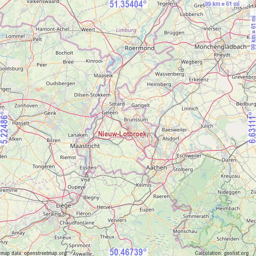
Nieuw-Lotbroek GPS coordinates[2]
50° 54' 46.188" North, 5° 55' 40.728" East
| Map corner | latitude | longitude |
|---|---|---|
| Upper-left | 51.35404°, | 5.22486° |
| Center: | 50.91283°, | 5.92798° |
| Lower-right: | 50.46739°, | 6.63111° |
| Map W x H: | 98.6×98.6 km | = 61.3×61.3mi |
| max Lat: | 53.48025° ⇑95.8% North |
| Nieuw-Lotbroek: | 50.91283° |
| min Lat: | ⇓4.2% South 50.76917° |
| min Long | Nieuw-Lotbroek | max Long |
| 3.38611° | 5.92798° | 7.16528° |
| W 66.2%⇐ | ⇒33.8% E |
Elevation
Elevation of Nieuw-Lotbroek is 83 m = 272 ft, and this is 68 m = 223 ft above average elevation for this country.
| Max E: |
203 m = 666 ft | 3.8% |
| Nieuw-Lotbroek | 83 m 272 ft | |
| Avg. | 15 m = 49 ft | |
Min E: |
-6 m = -20 ft | 96.2% |
See also: Netherlands elevation on elevation.city.
Geographical zone
Nieuw-Lotbroek is located in North temperate zone (between Tropic of Cancer and the Arctic Circle). Distance of this North polar circle is 1740.2 km =1081.3 mi to North.| Distance of | km | miles | from Nieuw-Lotbroek |
|---|---|---|---|
| North Pole | 4346.1 | 2700.5 | to North |
| Arctic Circle | 1740.2 | 1081.3 | to North |
| Tropic Cancer | 3055.1 | 1898.4 | to South |
| Equator | 5661 | 3517.6 | to South |


Nearby cities:
15 places around Nieuw-Lotbroek: (largest is in red/bold)
• Amstenrade
2.9 km =1.8 mi,  354°
354°
• Beersdal
2.7 km =1.7 mi,  106°
106°
• Heksenberg
3.3 km =2.1 mi,  74°
74°
• Hoensbroek
1.2 km =0.7 mi, 351°
• Hommert
2.7 km =1.7 mi,  340°
340°
• Husken
2.8 km =1.7 mi,  133°
133°
• Kunrade
3.9 km =2.4 mi,  176°
176°
• Mariarade
1.8 km =1.1 mi,  358°
358°
• Nuth
3 km =1.9 mi,  280°
280°
• Palemig
4 km =2.5 mi,  104°
104°
• Passart
1.8 km =1.1 mi,  46°
46°
• Vaesrade
2.3 km =1.4 mi,  320°
320°
• Voerendaal
3.3 km =2.1 mi, 177°
• Vrieheide
2.9 km =1.8 mi, 69°
• Wijnandsrade
3.2 km =2 mi,  256°
256°
Sources, notices
• [Note1] Compared only with cities in Netherlands existing in our database
• [Src1] Map data: © OpenStreetMap contributors (CC-BY-SA)
• [Src2] Other city data from geonames.org with taken over terms of usage.
• [Src3] Geographical zone / Annual Mean Temperature by Robert A. Rohde @ Wikipedia
